Imagine a world where you can conjure detailed satellite images merely through verbal descriptions. This is the groundbreaking capability of GeoSynth, a generative AI-driven system transforming satellite imagery. GeoSynth’s prowess in producing satellite images from text prompts unlocks new possibilities in environmental monitoring, urban planning, disaster response, and augmenting remote sensing data. Let’s explore this technological wonder and its far-reaching impact.
In their recent paper, “GeoSynth: Contextually-Aware High-Resolution Satellite Image Synthesis,” Sastry et al. [2024] introduce GeoSynth, a model that uses diffusion models and control mechanisms to generate satellite images based on user-defined parameters.
What is GeoSynth?
GeoSynth stands at the forefront of AI technology, transforming how we generate and utilize satellite images. Unlike traditional satellite imaging, which relies on capturing real-time data from orbiting satellites, GeoSynth uses sophisticated AI algorithms to interpret textual descriptions and create accurate, high-resolution satellite imagery. This innovation democratizes access to satellite data, making it faster, more cost-effective, and customizable.
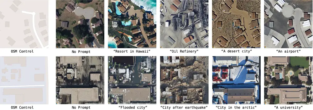
In brief, GeoSynth is a system for generating high-resolution satellite images with control over global style and image-specific layout. The control mechanisms are:
- Textual prompts: These specify the scene semantics, like “dense forest” or “urban sprawl.”
- Geographic location: This allows the model to capture the regional appearance of a place.
These controls can be used together for even more fine-grained image generation.
Training and Data
GeoSynth is trained on extensive datasets containing pairs of satellite images and corresponding text descriptions. High-resolution satellite imagery was paired with OpenStreetMap (OSM) images to build this dataset.
The pairs were randomly sampled near ten major US cities, with each location spaced at least 1 kilometer apart to improve coverage and reduce spatial bias. Each image is 512×512 pixels with an approximate ground sampling distance of 0.6 meters.
Initially, 90,305 image pairs were downloaded, but after filtering out images consisting entirely of bare earth, water, or forest, 44,848 pairs remained. The dataset was extended by captioning each satellite image using LLaVA, a multimodal large language model.
How GeoSynth Works to Create Satellite Images From Text Prompts?
GeoSynth’s magic lies in its complex yet fascinating methodology. GeoSynth’s development involved a suite of advanced models designed to synthesize satellite images from text prompts, geographic locations, and control images. Here’s a glimpse into its sophisticated framework:
Model Architecture
- Latent Diffusion Models (LDM): Central to GeoSynth, these models learn the conditional distribution on the satellite image text prompt, geographic location, and control image.
- Components:
- Encoder: Transforms raw images into a low-dimensional latent space.
- Pre-trained CLIP Text Encoder: Processes text prompts to generate latent text vectors.
- Diffusion Model: A U-Net based architecture with cross-attention blocks, it denoises latent vectors at each timestep conditioned on the text prompt.
- Decoder: Reconstructs images from latent vectors, with a Variational Autoencoder (VAE) style architecture.
- ControlNet Integration: A zero-initialized neural network attached to the LDM, ControlNet transforms feature maps of the LDM at each stage using 13 residual cross-attention blocks that take as input the control image, text prompt, and diffusion timestep.
- CoordNet for Geographic Features: To incorporate geographic location, SatCLIP extracts location-based features using spherical harmonics-based encoding. CoordNet, a ControlNet-style cross-attention-based transformer, processes these location embeddings. It consists of 13 layer multi-head cross-attention blocks that merge features from SatCLIP with those from ControlNet and LDM.
- Training and Inference: During training, the diffusion process operates in the latent space of raw images, learning to denoise a noisy latent vector conditioned on the text prompt. The LDM components and SatCLIP location encoder remain frozen. During inference, a noisy latent vector is sampled and progressively denoised using inputs from the CLIP text encoder, ControlNet, and CoordNet.

Applications of GeoSynth
GeoSynth’s versatility spans across numerous applications:
- Environmental Monitoring: Track deforestation, pollution levels, and other environmental changes in real-time, enabling proactive responses to ecological shifts.
- Urban Planning: Visualize potential development scenarios, assess infrastructure needs, and plan sustainable cities with tailored, high-resolution cityscapes.
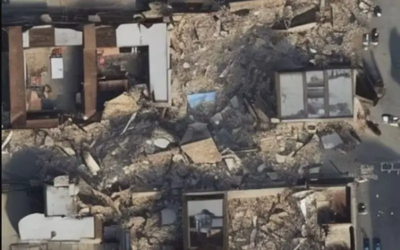
- Disaster Response: Generate immediate post-disaster imagery to aid in rescue and relief operations, providing critical visual data for efficient resource deployment.
Benefits of GeoSynth
GeoSynth offers several advantages over traditional satellite imaging:
- Speed and Efficiency: Generate images almost instantaneously, providing rapid access to critical data.
- Accessibility and Cost-Effectiveness: Reduce costs and logistical challenges associated with obtaining satellite imagery, making it accessible to a broader range of users.
- Customization of Satellite Imagery: Create images tailored to specific needs and scenarios, enhancing precision and context-specific data.
Challenges and Limitations
GeoSynth is a general framework for synthesizing satellite images that combines various state-of-the-art components. Its synthesis performance highly depends on each component, particularly the geo-awareness, restricted by SatCLIP’s ability to represent geography.
SatCLIP embeddings show limitations in capturing high-frequency geographic information. However, SatCLIP can be replaced with other location encoders. Currently, GeoSynth supports RGB-based satellite images, but it can be extended to other modalities like depth and radar.
Despite its groundbreaking capabilities, GeoSynth faces some other challenges:
- Accuracy Concerns: The accuracy of AI-generated images can vary, especially in complex or unfamiliar terrains, necessitating continuous refinement and validation of algorithms.
- Ethical Considerations: The ability to generate realistic satellite images raises ethical questions about data manipulation, privacy, and potential misuse, requiring established guidelines and regulatory frameworks.
Conclusion
GeoSynth represents a remarkable leap forward in satellite imaging technology. By harnessing the power of AI to generate images from text prompts, it offers unprecedented speed, accessibility, and customization.
While challenges remain, the potential applications and benefits of GeoSynth are vast, promising significant advancements across various fields.
As technology continues to evolve, GeoSynth stands as a testament to the transformative power of artificial intelligence in reshaping our understanding and utilization of satellite imagery.
For more detailed information on the methodology, you can refer to the paper: GeoSynth: Contextually-Aware High-Resolution Satellite Image Synthesis.
The code and model checkpoints are available at this https URL.


