GNSS Jamming Crisis at the Strait of Hormuz Exposes Maritime Navigation Vulnerabilities
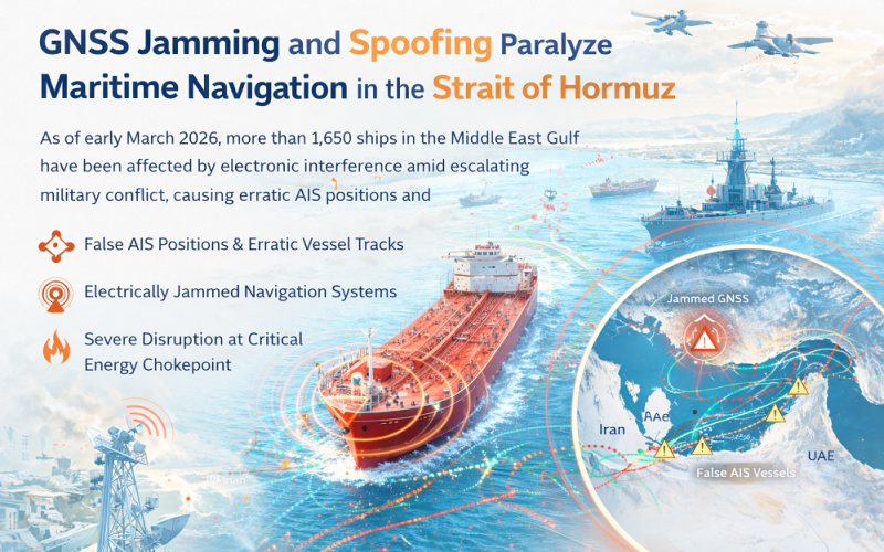
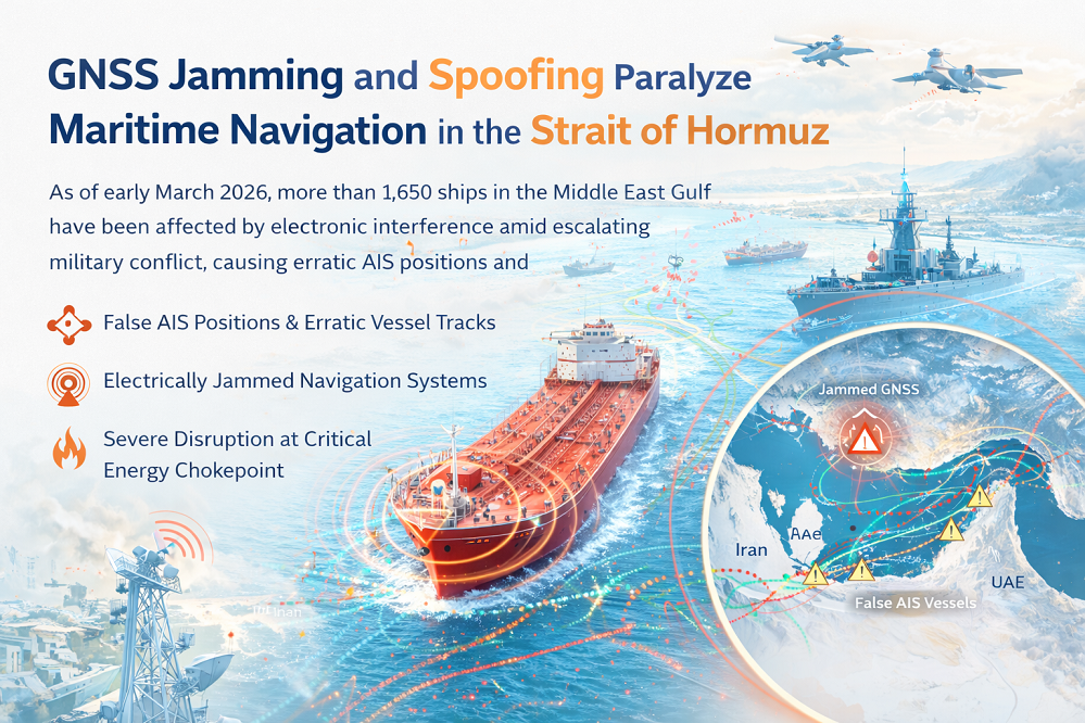
Widespread GNSS jamming and GPS spoofing have disrupted navigation for more than 1,650 ships in the Middle East Gulf as of early March 2026, turning the Strait of Hormuz into a live stress-test for global maritime positioning infrastructure. The electronic interference — coinciding with escalating military conflict in the region — is producing false Automatic Identification System (AIS) positions, erratic vessel tracks, and near-complete commercial shipping paralysis in one of the world’s most critical energy chokepoints.
Background: GNSS Vulnerability in Conflict Zones
Electronic interference with Global Navigation Satellite Systems (GNSS) — the umbrella framework encompassing GPS (USA), GLONASS (Russia), Galileo (EU), BeiDou (China), and NavIC (India) — has become increasingly prevalent in conflict zones since the Russian invasion of Ukraine in 2022. The Strait of Hormuz, a narrow waterway between Iran and the UAE through which approximately 20 percent of the world’s oil and gas exports transit, was already experiencing intermittent interference from mid-2025. Since military escalation on 28 February 2026, the scope of disruption has increased exponentially. The Royal Institute of Navigation and maritime analytics firm Windward have both classified the current situation as unprecedented in scale for a commercial shipping context.
Also Read – GPS: Solar Flares and Jamming
GNSS Jamming and Spoofing: Technical Mechanisms and Positioning Impacts
Jamming versus Spoofing
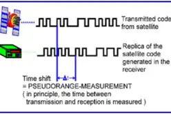
GNSS signals originate from satellites orbiting at approximately 20,200 kilometres altitude and arrive at Earth’s surface extremely weak — typically around -130 dBm. GNSS jamming exploits this vulnerability by flooding receiver frequencies with stronger radio noise, preventing a receiver from locking onto satellite signals and completely denying position, navigation, and timing (PNT) data. GNSS spoofing is more sophisticated: false satellite-like signals are broadcast to trick a receiver into computing and reporting an incorrect position. Ships affected by spoofing near Hormuz have been shown on AIS tracking maps as clustered in perfect geometric circles over airports, nuclear facilities, or land — telltale signatures of systematic position falsification.
Downstream Impacts on Maritime GIS Systems
Spoofed or jammed positions propagate into maritime Electronic Chart Display and Information Systems (ECDIS) and AIS networks, which treat satellite-derived coordinates as authoritative. This creates false compliance alerts, potential regulatory violations from apparent territorial incursions, and critically impairs collision avoidance in congested waters. The Joint Maritime Information Centre (JMIC) reported more than 600 individual GNSS disruption events within a single 24-hour period, resulting in AIS anomalies and intermittent signal degradation across the Strait of Hormuz, Gulf of Oman, and Persian Gulf.
Affected Area and Operational Response
By 7 March 2026, maritime traffic through the Strait had fallen to near-zero levels, with only three total vessel crossings recorded in a single day. Major war-risk insurers including Gard, Skuld, NorthStandard, and others withdrew coverage for Gulf and Iranian waters. Container carriers such as Maersk and CMA CGM rerouted or suspended services. JMIC advised mariners to increase reliance on radar ranges, visual bearings, and cross-system navigation checks rather than GNSS alone.
Applications and Policy Implications for GNSS
The crisis underscores the critical vulnerability of civilian GNSS infrastructure and the urgent need for resilient Position, Navigation, and Timing (PNT) architectures that do not rely exclusively on satellite signals. Solutions under discussion include multi-constellation receivers, inertial navigation systems (INS) as backups, terrestrial eLoran systems, and the adoption of Galileo’s Open Service Navigation Message Authentication (OSNMA) feature, which enables receivers to verify the authenticity of incoming signals. The Galileo system introduced this authentication capability in 2025.
Conclusion
The GNSS disruption in the Strait of Hormuz marks a defining moment for the geospatial and navigation community: the era of reliable, uncontested civilian satellite positioning has ended in conflict-adjacent regions. As electronic warfare becomes standard practice, investment in resilient, multi-source PNT systems is no longer optional for critical maritime and aviation infrastructure.
References
1. Inside GNSS (2026, March). GNSS Interference Complicates Navigation as Hormuz Shipping Disruption Deepens. https://insidegnss.com
2. CNN (2026, March 6). Ships and planes are vulnerable to GPS jamming. https://www.cnn.com
3. France24 (2026, March 6). Surge in GPS interference around Strait of Hormuz increases shipping risks. https://www.france24.com
4. Windward Maritime AI (2026, March). Widespread GPS Jamming Hits 1,000-plus Ships in the Middle East. https://windward.ai
5. gCaptain (2026, March 9). Critical Threat Persists in Hormuz as Attacks and GPS Jamming Shake Shipping. https://gcaptain.com