In a recent announcement on the website of the Ministry of Commerce and Industry Government of India, Minister Piyush Goyal said that the Ministry is going to set up a single-window system for clearances and approvals of the industry in the country.
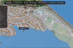
The Minister said that the Government has launched a national GIS-enabled land bank which will facilitate the potential investors to locate and identify the land banks from the comfort of the office. The investor can finalize the location of industries without frequent visits to site locations or offices of land-owning agencies.

Image Credit: Portwings
The land bank system will be powered using Geographical Information System (GIS) technology which will allow real-time information about the availability of industrial land and resources. The national GIS-enabled land bank system is being developed by integrating the Industrial Information System (IIS) with state GIS.
Initially, the system has been launched in six states. The system will be improved further to make it an effective, transparent mechanism of land identification as well as procurement.
More than 3,300 industrial parks across 31 States/UTs covering about 4,75,000 hectares of land have been mapped on the system. As of now, six States have already given their consent to register and share the data through the portal.
This is a prototype only and will be developed further with inputs from States, to make it an effective, transparent mechanism of land identification and procurement,” an official release quoted the Minister. The other States and Union Territories were likely to be on board by December.
Piyush Goyal
The e-launch took place at a virtual meeting Goyal had with the industry ministers of States, UT administrators, and senior officers of the Central and State governments.
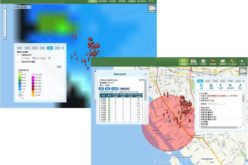
The information available on the portal includes that of forests, drainages, raw material heat maps (agricultural, horticulture, mineral layers), and multiple layers of connectivity.
The initiative is being supported by Invest India, National Centre of Geo-Informatics, National e-Governance Division, Ministry of Electronics & Information Technology and Bhaskaracharya Institute for Space Applications and Geo-Informatics.
The Minister said that the Government had initially identified 12 industrial sectors to focus upon, and the same has been expanded to 20. This will help in scaling up investment and leveraging the competitive edge of the country. These sectors include furniture – standard as well as special furniture, air-conditioners, leather, footwear, agro-chemicals, Ready to eat food, Steel, Aluminium, Copper, Textiles, Electric Vehicles, Auto-components, TV Set-Top Boxes, CCTVs, Sports goods, ethanol manufacture, and bio-fuels, and Toys.
He said that Aatmanirbhar Bharat does not mean India is closing the doors for the world but widening its doors for opportunities and Investment with the focus on the quality of the Indian products, increasing economies of scale for the production in India.
The country will deal with the world from a position of strength, become more competitive, and imbibes the best technology and equipment. The industry should assimilate artificial intelligence, data analytics, robotic, and all other best practices.
He said using technology does not imply loss of lobs in any way, as a jump in production in the country will lead to the creation of more jobs.
Other source – The Hindu and PTI
You may also like this – Kerala is the First State to Embark Land Resources Information System (LRIS) – India