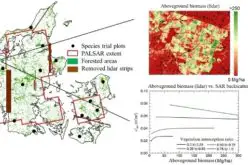
Regional Equivalent Water Thickness Modeling from Remote Sensing across a Tree Cover/ LAI Gradient in Mediterranean Forests of Northern Tunisia
Regional Equivalent Water Thickness Modeling from Remote Sensing across a Tree Cover/LAI Gradient in Mediterranean Forests of Northern Tunisia
– Hedia Chakroun, Florent Mouillot and Abdelaziz Hamdi
 Abstract:
Keywords: equivalent water thickness; biomass vegetation indexes; moisture vegetation indexes; moderate resolution imaging spectroradiometer (MODIS); leaf area index (LAI); Mediterranean forests