Newly designed US Topo maps covering West Virginia, New Jersey and Georgia are now available online for free download
Image Source: worldofmaps.net
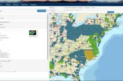
US Topo maps now
This new design was launched earlier this year and is now part of the new US Topo quadrangles for West Virginia (418 maps), New Jersey (150) and Georgia (952 maps), replacing the first edition US Topo maps for those states.
“Users in West Virginia will appreciate improvements in the US Topo product, including the availability of improved contours, Forest Service trails, and vegetation cover (green tint),” said Craig Neidig, USGS Geospatial Liaison for West Virginia. “The product should find an audience among the many recreational users and outdoor enthusiasts in West Virginia, especially with the capability to use the US Topo maps on mobile devices. We look forward to the addition of layers including mining sites, wetlands, and more historic features that users were accustomed to seeing on the old topographic quadrangles for the Mountain State.”
US Topo maps are updated every three years. The initial round of the 48 conterminous states coverage was completed in September of 2012. Hawaii and Puerto Rico maps have recently been added. More than 400 new US Topo maps for Alaska have been added to the USGS Map Locator & Downloader, but will take several years to complete.
Re-design enhancements and new features:
- Crisper, cleaner design improves online and printed readability while retaining the look and feel of traditional USGS topographic maps
- New functional road classification schema has been applied
- A slight screening (transparency) has been applied to some features to enhance visibility of multiple competing layers
- Updated free fonts that support diacritics
- New PDF Legend attachment
- Metadata formatted to support multiple browsers
- New shaded relief layer for enhanced view of the terrain
- Military installation boundaries, post offices and cemeteries
- Starting with Georgia, the railroad dataset is much more complete from a new contractor
To enjoy earlier legacy quads for West Virginia, New Jersey and Georgia, go to the USGS Historical Topographic Map Collection. These scanned images of paper maps up through 2006 are also available for free download from The National Map and the USGS Map Locator & Downloader website.


US Topo maps are created from geographic datasets in The National Map, and deliver visible content such as high-resolution aerial photography, which was not available on older paper-based topographic maps. The new US Topo maps provide modern technical advantages that support wider and faster public distribution and on-screen geographic analysis tools for users. The new digital electronic topographic maps are delivered in GeoPDF image software format and may be viewed using Adobe Reader, available as a no cost download.
For more information, go to: http://nationalmap.gov/ustopo/
Contact Information:
Mark Newell, APR ( Phone: 573-308-3850 ); Bob Davis ( Phone: 573-308-3554 )