With assistance from Helix SRL, Supergeo’s partner in Italy, the Romanian company Black Light SRL has recently selected the well-known mobile GIS software SuperSurv as its mobile geospatial solution.
Established in 1992, Black Light SRL is a surveying company with numerous branch offices across Romania, a country with diverse landforms. Since its founding in Timisoara, Black Light has demonstrated a long-term commitment to providing high quality and customized services in the field of land measurement and computer-aided design.
Also, Black Light is an authorized distributor of a wide variety of equipment and software, to fulfill the demands of consulting and also provide the expertise to implement diverse geospatial projects.
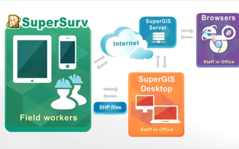
SuperSurv is the mobile GIS software developed especially for smart devices by Supergeo Technologies Inc. Users can download SuperSurv directly from the app stores of two mainstream platforms – Android and iOS. In addition to general mobile GIS functions such as data collection, map display and waypoint guidance, SuperSurv also offers extra convenience for web map services. Users can switch their basemap to cached map, OpenStreetMap or map services generated by SuperGIS Server with ease. By synchronizing with SuperGIS server, the surveying workers in the field can receive and correct the data sent from the office instantly, leading to a smoother surveying workflow.
Learn More about Functionalities of SuperSurv:
http://www.supergeotek.com/ProductPage_SuperSurv.aspx?Type=Functionality
Try SuperSurv Now:
http://www.supergeotek.com/download_6_mobile.aspx