Rapid ice loss in a remote Arctic ice cap has been detected by the Sentinel-1A and CryoSat satellites.
Located on Norway’s Nordaustlandet island in the Svalbard archipelago, parts of the Austfonna ice cap have thinned by more than 50 m since 2012 – about a sixth of the ice’s thickness.
Over the last two decades, ice loss from the southeast region of Austfonna has increased significantly, and ice thinning has spread over 50 km inland and is now within 10 km of the summit.
The ice cap’s outlet glacier is also flowing 25 times faster, from 150 m to 3.8 km per year – half a metre per hour.
In the study published in Geophysical Research Letters, a team led by scientists from the Centre for Polar Observation and Modelling (CPOM) at the University of Leeds in the UK combined observations from eight satellite missions, including Sentinel-1A and CryoSat, with results from regional climate models.
“These results provide a clear example of just how quickly ice caps can evolve, and highlight the challenges associated with making projections of their future contribution to sea level,” said the study’s lead author, Dr Mal McMillan.
“New satellites such as Sentinel-1A and CryoSat are essential for enabling us to systematically monitor ice caps and ice sheets, and to better understand these remote polar environments.”
Sentinel-1A, the first satellite developed for Europe’s Copernicus programme, was launched in April last year, while CryoSat has been in orbit since 2010.

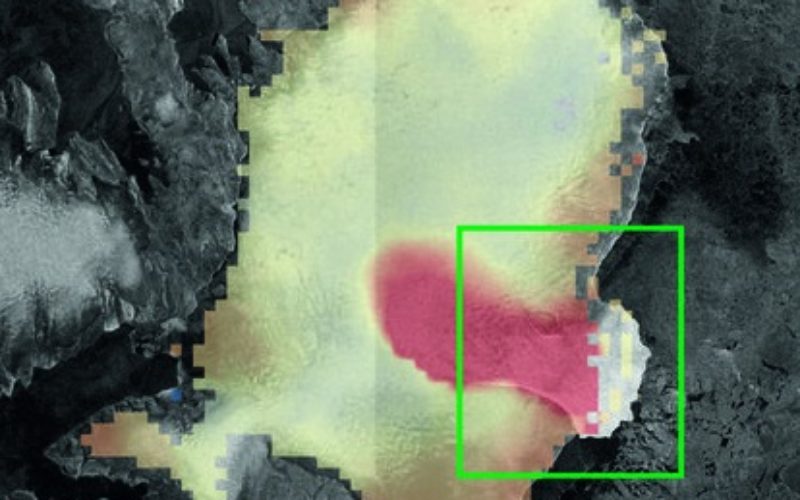
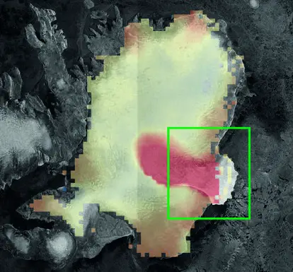
A closer look at the southeast region is shown in the four smaller figures below. These figures show the evolution of ice velocity over the last two decades. Ice velocity in 2014 was mapped using Sentinel-1A and the DLR German Aerospace Center’s TerraSAR-X mission. Credit: CPOM/GRL
Melting ice caps and glaciers are responsible for about a third of recent global sea-level rise. Although scientists predict that they will continue to lose ice in the future, determining the exact amount is difficult, owing to a lack of observations and the complex nature of their interaction with the surrounding climate.
“Glacier surges, similar to what we have observed, are a well-known phenomenon,” said Professor Andrew Shepherd, Director of CPOM.
“However, what we see here is unusual because it has developed over such a long period of time, and appears to have started when ice began to thin and accelerate at the coast.”
There is evidence that the surrounding ocean temperature has increased in recent years, which may have been the original trigger for the ice cap thinning.
“Whether or not the warmer ocean water and ice cap behaviour are directly linked remains an unanswered question.
“Feeding the results into existing ice flow models may help us to shed light on the cause, and also improve predictions of global ice loss and sea level rise in the future.”
Long-term observations by satellites are crucial for monitoring such climate-related phenomena in the years and decades to come.