Soil moisture is a key variable in controlling the exchange of water and heat energy between the land surface and the atmosphere through evaporation and plant transpiration. An assessment of surface soil moisture is necessary for applications such as weather forecasting, climate change modeling, monitoring of agricultural productivity, water resources management, drought prediction, flood area mapping, and ecosystem health monitoring. Taking measurements with high levels of accuracy and resolution (spatial and temporal) is therefore vital for these and other applications, whose outcomes have direct impacts on the global environment and human society.
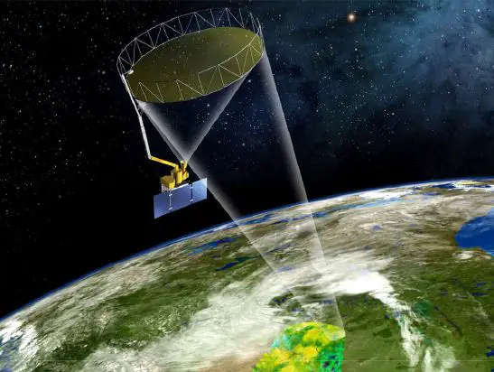
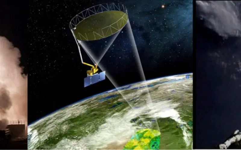
The Soil Moisture Active Passive (SMAP) observatory orbits the Earth pole-to-pole at 685 km altitude. The instrument spins during orbit, allowing the coverage of a 1000 km-wide swath. The system maps the global surface every two to three days. Credit: SPIE
To record such measurements, NASA has developed the Soil Moisture Active Passive (SMAP) mission, whose science objectives are to understand processes that link the terrestrial water, energy, and carbon cycles; to estimate global water and energy fluxes at the land surface; to quantify net carbon flux in boreal landscapes; to enhance weather and climate forecast skill; and to develop improved flood prediction and drought monitoring capabilities.
The observatory launched on 31 January 2015 atop a Delta II vehicle from Vandenberg Air Force Base. The mission went through its commissioning phase for observatory checking and orbit adjustment between February and April 2015, and there now follows one year of intensive calibration and validation activities to adjust instrument and algorithm parameters. SMAP uses an L-band radar (in the range 1–2GHz on the radio spectrum) and an L-band radiometer for concurrent, coincident measurements integrated as a single observation system.
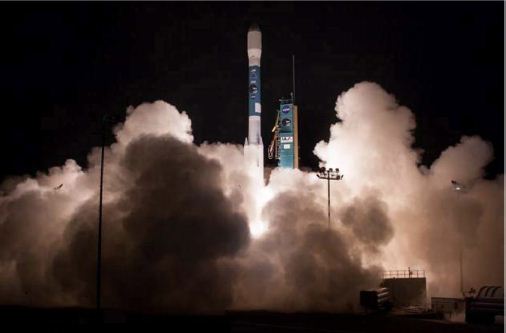
The SMAP observatory launched aboard a Delta II vehicle from Vandenberg Air Force Base at 6:22 AM Pacific Standard Time on 31 January 2015. Credit: SPIE
The SMAP have active (L-band radar) and passive (L-band radiometer) microwave measurement approach, combining the two measurements with a shared antenna. SMAP provide global mapping capabilities with frequent revisit are advanced capabilities are particularly advantageous for the measurement of surface soil moisture.
The radar and radiometer instruments share the same feed and a rotating 6m mesh-deployable reflector antenna, offering the relative strengths of both active (radar) and passive (radiometer) microwave remote sensing for soil moisture mapping.
At L-band, the microwave emission (brightness, temperature) measured by the radiometer mostly emanates from the top ~5cm and is clearly sensitive to soil moisture in regions with vegetation water content of up to ~5kg/sq. m averaged over the radiometer resolution footprint of ~40km. The SMAP L-band synthetic aperture radar provides backscatter measurements at higher resolution (~1–3km) than the coarser-resolution radiometer. However, the radar’s accuracy is limited for soil moisture sensing by the higher sensitivity of radar to surface roughness and vegetation scattering.
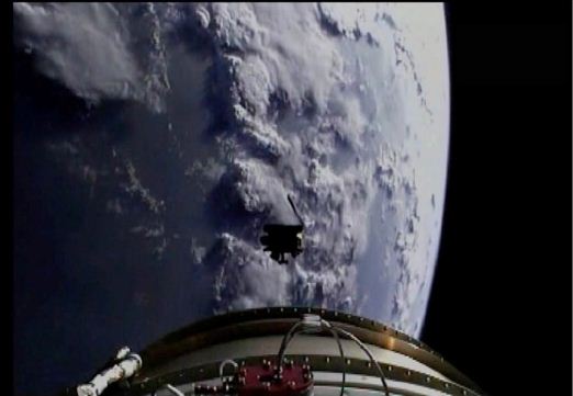
The SMAP observatory separated from the upper stage 57 minutes after liftoff, and solar arrays opened one minute after separation. Credit: SPIE
SMAP’s significant advantage is the concurrent L-band radar and radiometer measurement capability, enabling soil moisture estimates with accuracy and resolution (~9km) that meet Earth science application requirements. An image captured from the second stage of the Delta II rocket shows the SMAP observatory separating from the launch vehicle.
The SMAP global mapping radar backscatter and radiometer brightness temperature measurements also enable path breaking new capabilities for monitoring the oceans and the terrestrial biosphere. The measurements can be used for mapping sea-ice coverage, ocean surface winds, and possibly ocean salinity. Over land the measurements add the capability to estimate vegetation properties regardless of cloud cover and solar illumination. Low-frequency active and passive microwave sensing enhances the capability to sense and monitor Earth surface processes.
– SPIE Newsroom (10.1117/2.1201506.005921)
Article Originally Authored by: Dara Entekhabi, Simon Yueh, Peggy O’Neill, Kent Kellogg, Eni Njoku, and Jared Entin