
Tag "geospatial"
New Airbus Aerial Technology Impacts Hurricane Irma Recovery Efforts
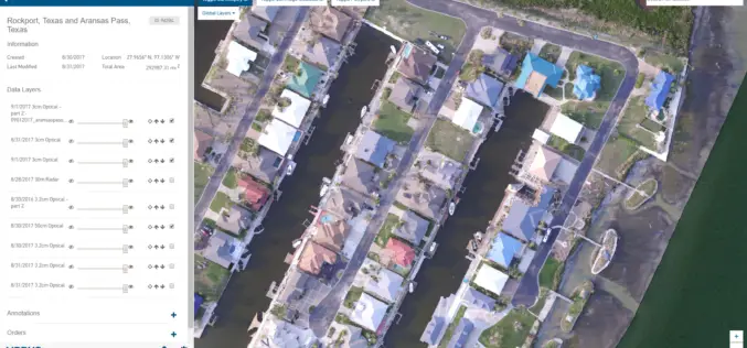
September 12, 2017 – As residents and insurers in the southeastern United States begin to consider recovery efforts following Hurricane Irma, Airbus Aerial is prepared to help by providing insurance

PCI Geomatics Releases Geomatica 2017, Service Pack 1
MARKHAM, Ontario, Canada, September 12, 2017 – PCI Geomatics, a world leading developer of remote sensing and photogrammetric software and systems, announced today the release of Service Pack 1 for

Indian Railways to Install GPS in all Hand-pushed Trolleys Used for Track Inspection
September 8, 2017 – PTI – The railway ministry has decided to install GPS trackers in all hand-pushed trolleys used to inspect the tracks. In a letter to all zonal

OGC Approves Community Standard for Streaming 3D Content
September 06, 2017 – The Open Geospatial Consortium (OGC®) membership has approved a new 3D standard for content strategy. This standard is focused on high performance visualization and spatial analysis

Pix4D Among UAV Industry Leaders Intel® Uses to Launch Intel Insights Platform
September 7, 2017 – Yesterday at InterDrone, Intel CEO Brian Krzanich announced the new Intel Insight Platform that will allow select enterprise customers to accelerate the path from drone flight to
OGC Seeks Public Comment on Proposed Geocoding API Standards Working Group
September 5, 2017 – The Open Geospatial Consortium (OGC®) is requesting comments on the draft charter for an OGC Geocoding API Standards Working Group (SWG). Geocoding is the act of linking

DigitalGlobe Delivers WorldView-4 High-Resolution Satellite Imagery to Power PSMA Australia’s Continent-scale Mapping Initiative
WorldView-4 Imagery To Become Available To All Commercial Customers On August 31 WESTMINSTER, Colo.–(BUSINESS WIRE)–Aug. 29, 2017– DigitalGlobe, Inc. (NYSE: DGI), the global leader in Earth imagery and information about our changing planet,
Boundless Donates $100,000 to LaunchCode in Support of CoderGirl Education Program
Donation Will Be Used to Support and Expand Program Throughout the St. Louis Area NEW YORK – August 29, 2017 – Boundless, the leader in open GIS, today announced that it

China, Russia to Sign Agreement to Boost Space Cooperation
Beijing, Aug 28 (IANS): China and Russia are set to sign a milestone agreement on joint space exploration from 2018 to 2022, the media reported on Monday. The deal is expected

Malaysian Geospatial Master Plan to be Completed in 2018
August 22, 2017 – Putrajaya, Malaysia: The Natural Resources and Environment Ministry (NRE) is developing the National Geospatial Master Plan (NGMP) towards realising the potential of geospatial technology, in line with the
