
Tag "geospatial"

Kongsberg Geospatial Collaborating with Wind River for Safety-Critical Geospatial Applications
October 24, 2017 – Ottawa, CA: Kongsberg Geospatial, an Ottawa-based developer of geospatial software technology, announced today that they are collaborating with Wind River® to validate their safety-critical geospatial components for

4DMapper Incorporates Global Mapper SDK Enabling Cloud Based Geospatial Analytics
Hallowell, Maine – October 23, 2017 – Blue Marble Geographics (bluemarblegeo.com) is pleased to announce that 4DMapper (4dmapper.com), a geospatial technology company based in Australia, has chosen the Global Mapper Software
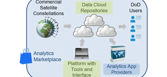
DARPA Seeks to Harness Commercially Available Geospatial Imagery for Defense Analysis
According to recent news published on DARPA.mil, DARPA’s new Geospatial Cloud Analytics (GCA) program seeks to enable instant access to the most up-to-date images anywhere in the world, as well as

Goa-based Transerve Technologies Raises $1.6mn Funds
Panji, Goa – According to recent news by the TOI and SMEPost.com, Goa-based Transerve Technologies, a company that offers geospatial technology-based SaaS solutions for sustainable growth and urban planning, has raised

OSGeo Signs MoU with U.S. Department of Interior
Osaka, Japan, 29 September 2017: The Open Source Geospatial Foundation has signed a Memorandum of Understanding with the United States Department of Interior (DOI). The agreement enables both organizations to

Geospatial Technology to Support National Mission for Clean Ganga
September 29, 2017 – New Delhi – (IANS) – Union minister of state for Water Resources, River Development and Ganga Rejuvenation Satyapal Singh on Thursday asked the officials of National Mission

Reliance Energy Launches App for Complaints on Defective Street Lights
September 28, 2017, Mumbai – (IANS) – In an effort to make Mumbai streets safer after dark, Reliance Energy has launched a new app-based service for lodging complaints on defective street lights,
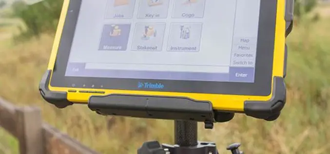
Trimble Introduces High-Performance T10 Tablet for Geospatial Field Applications
BERLIN, Sept. 26, 2017—Trimble (NASDAQ: TRMB) introduced today the Trimble® T10 tablet, a rugged, high-performance data processing platform suitable for a variety of survey and Geographic Information System (GIS) applications.
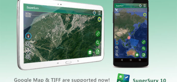
SuperSurv 10.1 Supports New Raster Formats and Online Maps
As the information technology constantly evolves, the geospatial industry also grows fast. Currently, including many open source projects, numerous services are providing online maps to geospatial professionals. As professional and
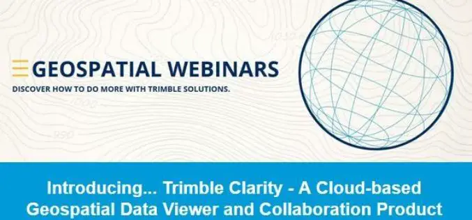
Introducing Trimble Clarity – A Cloud-based Geospatial Data Viewer and Collaboration Product
Introducing Trimble Clarity – A Cloud-based Geospatial Data Viewer and Collaboration Product September 27, 2017 Join us live from the Intergeo Geospatial Conference in Berlin, Germany as we present Trimble
