
Tag "Land Information System"

ISRO Successfully Launches Cartosat-2 Series Satellite Along with 30 Co-passenger Satellites
Jun 23, 2017 – ISRO’s Polar Satellite Launch Vehicle PSLV-C38 successfully launched the 712 kg Cartosat-2 Series Satellite along with 30 co-passenger satellites today (June 23, 2017) from Satish Dhawan Space
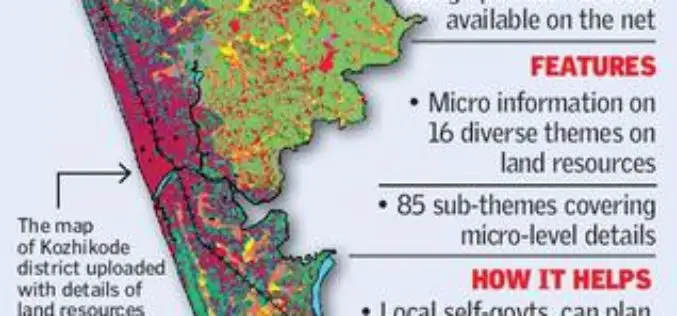
Kerala Launches GIS-based Land Information System
According to recent news by The Hindu, Kerala State Land Use Board (KSLUB) has launched Geographical Information System-based Land Resources Information System (LRIS). A 20-member team of the KSLUB has come out

Great Day in Indian Space History With the Launch of 20 Satellites in a Single Mission
In its thirty sixth flight (PSLV-C34), ISRO’s Polar Satellite Launch Vehicle successfully launched the 727.5 kg Cartosat-2 Series Satellite along with 19 co-passenger satellites on June 22, 2016 from Satish

Isro to Launch Cartosat-2 Series Satellite Mission : Scheduled on June 22, 2016
India’s Polar Satellite Launch Vehicle, in its thirty sixth flight (PSLV-C34), will launch the 727.5 kg Cartosat-2 series satellite for earth observation and 19 co-passenger satellites together weighing about 560 kg
