
Archive

PrecisionHawk Brings Its Drone Data Platform to Australia
The launch of a Sydney office and partnership with agricultural powerhouse Ruralco, brings PrecisionHawk’s drone and data packages close to home for growers and businesses to get started with the

PDF3D Announces Support for macOS Sierra
Advanced 3D PDF authoring software suite supports the latest Macintosh® OS release. London, UK, October 27th, 2016 – PDF3D, from Visual Technology Services, today reaffirmed its commitment to Apple technology

IBM and Esri Team Up to Offer Cognitive Analytics and IoT in the IBM Cloud
Redlands, California—At this year’s IBM World of Watson event in Las Vegas, global smart mapping leader Esri announced that it now works with IBM users and developers to broaden the
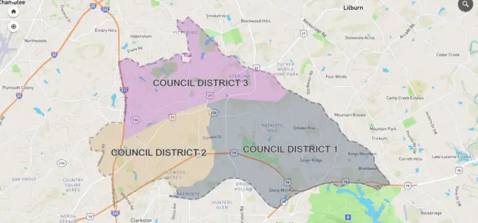
City of Tucker Launches New GIS Platform from InterDev; Debuts Web Application
Tucker, GA and Alpharetta, GA – October 25, 2016 — InterDev, an Atlanta-area provider of information technology, security and geographic information (GIS) services, today announced the City of Tucker has

PHOTOMOD Technical Seminar in Agra, India – Limited Offer
PHOTOMOD technical seminar will take place on November 16 (Wednesday). This free seminar provides a forum for professionals working in the field of photogrammetry and covers topics related to increasing

Sharjah to Conduct GIS Survey of Labour Housing Facilities
According to the recent news, the Sharjah Labour Standards Development Authority (SLSDA) is planning to adopt geographic information system (GIS) and mobile apps to survey labour accommodation in Sharjah. The Sharjah
OGC Requests Comments on Proposed Quality of Service and Experience DWG
The Open Geospatial Consortium (OGC®) requests comments on the charter for a proposed Quality of Service and Experience (QoSE) Domain Working Group (DWG). Spatial data now plays a critical role

Central Government Directs Chandigarh to Complete Aerial Mapping Project Within 1 Year
According to recent news by The Indian Express, The Union government on has directed the Chandigarh administration to complete the project of digitization of land records in the city within the

Sanborn Completes Kentucky County Aerial Project
Delivers Ortho and Oblique Imagery on Time to Boone County GIS Colorado Springs, Colo. (Oct. 24, 2016)—The Sanborn Map Company, Inc. (Sanborn) has completed a project for Boone County GIS

NOAA Offers LiDAR Coastal Mapping Training
The National Oceanic and Atmospheric Administration (NOAA) has launched a self-paced, 80-minute online training introducing several fundamental concepts of LiDAR to help you get more out of your LiDAR point cloud data. The
