
Tag "mapping"
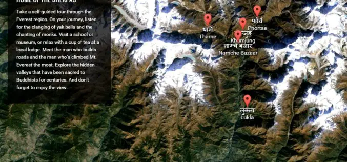
Climb the Mount Everest with Google Street View
Google has added the Khumbu region of Nepal, famously known as the Mount Everest region, to its Street View with extensive mapping and photographs. Google has now taken street view

Railways to Digitize Mapping of Land Records to Counter Encroachment of Railways Land
The Union Railway Minister Shri Suresh Prabhakar Prabhu has said that encroachment on the Railway Land is a serious issue and to counter this, digitized mapping of land records has

Webinar: AirGon Presents small UAS Metric Mapping Workflows
AirGon Presents small UAS Metric Mapping Workflows Wed, Mar 4, 2015 2:00 PM – 3:00 PM CST In this webinar we will be taking a look at a complete workflow
Digital Aerial Solutions Expands Mapping Services with Purchase of Leica ALS80 Laser Scanner
Leica Geosystems Inc. today announced that Digital Aerial Solutions (DAS), a woman-owned small business based in Tampa, Fla., is the first company in North America to purchase the ALS80 laser

Automatic Disaster Analysis and Mapping System Speed Up Earthquake Aid Response
The Automatic Disaster Analysis and Mapping system (ADAM) pulls information from the U.S. Geological Survey, World Bank and World Food Programme databases, getting aid workers vital facts from earthquake zones

New Book from Esri Shows How GIS Supports Weather, Climate Research
Redlands, California—Weather mapping goes beyond what’s broadcast on the evening news. The new book Mapping and Modeling Weather and Climate with GIS, from Esri Press, describes how geographic information system
Topcon Announces New Millimeter GPS Laser Transmitter
LIVERMORE, Calif., USA/ CAPELLE A/D IJSSEL, The Netherlands – 3rd February 2015 – Topcon Positioning Group announces the release of the next generation laser transmitter for use with its Millimeter

LizardTech Releases Updated GeoViewer Application for iOS
SEATTLE, Wash. — Feb. 9, 2015 —LizardTech®, a provider of software solutions for managing and distributing geospatial content, has released an update to its free iOS GeoViewer application for viewing

NASA First Ever Mapped Greenland’s Ice Sheet in 3D
Scientists using ice-penetrating radar data collected by NASA’s Operation IceBridge and earlier airborne campaigns have built the first-ever comprehensive map of layers deep inside the Greenland Ice Sheet. This new

Google Free Mapping Service Adds Local Guides
San Francisco: An update to Google`s free online mapping service on Friday let users become local guides who post reviews of businesses and venues in a challenge to
