
A Conversation with the USGS: The National Elevation 3D Program (3 DEP)
Tuesday, April 29, 2014 1:00 PM – 2:00 PM CDT
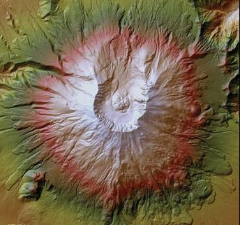
High-resolution lidar image of Mount St. Helens, WashingtonImage Credit: USGS
The United States Geological Survey is embarking on the most ambitious 3D Mapping program ever undertaken within the United States. The national 3D elevation program (3DEP) is designed to provide the first high resolution elevation data coverage for the country much as the USGS digital orthophoto program did for imagery in the 1990s. This initiative is being developed by the USGS to respond to the growing need for high-quality topographic data and other three-dimensional representations of the Nation’s natural and constructed features.
Speaker:
This topic will be presented by Ms. Vicki Lukas of USGS. Ms. Lukas has more than 20 years of experience as a geographer with the U.S. Geological Survey. As Chief of the Topographic Data Services Team for the National Geospatial Program, she oversees the 3D Elevation Program, the National Hydrography Dataset and associated activities.
How to Register
Click to Register Now