
Archive

Ordnance Survey Maintaining National Coverage of Paper Maps Across Great Britain
March 31, 2014 – There have been a number of articles in the media this weekend reporting that Ordnance Survey is to end its policy of routinely producing maps that cover

Leica GeoMoS Adjustment v1.7: Adjusted Monitoring Network Data Available Everywhere and Quickly
Leica GeoMoS Adjustment, the network adjustment add-on for the successful Leica GeoMoS monitoring software, is intended for use in projects where the most precise and reliable information on structural movement
Join Webinar – Scripting in gvSIG Desktop 2
MundoGEO and gvSIG Association invite you to participate in an online seminar in which the details of the extension in gvSIG scripting 2 will be explained, and wherein an example

Exprodat’s Petroleum ArcGIS Training Comes to Calgary
Exprodat, the UK-based provider of Esri-based petroleum GIS services, software and training will be visiting Alberta in Canada at the end of April 2014, to offer their wide-range of oil

PR: Synthicity Releases 3D Spatial Data Visualization Tool, GeoCanvas
New Software Streamlines GIS Berkeley, California – Synthicity has released (on March 26, 2014) a free public beta version of GeoCanvas, its 3D spatial data visualization tool. The software provides

GRASS GIS 7.0.0 beta 1 is Released
What’s new in GRASS GIS 7.0.0 beta in a nutshell: The graphical user interface based on wxPython (introduced in GRASS GIS 6.4) has been enriched with many new features in
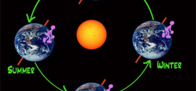
Northern Seasons are Shifting: Study
Scientists have discovered a shift in the northern seasons, with spring arriving early and autumn being delayed. Peter Atkinson, professor of geography at the University of Southampton, has examined satellite
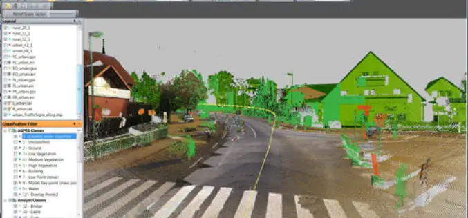
PR: Trimble Launches New Version of its eCognition Software for Advanced Geospatial Data Analysis
LOUISVILLE, Ky., March 28, 2014—Trimble (NASDAQ: TRMB) announced today the latest version of its eCognition® software for geospatial data analysis at the American Society for Photogrammetry and Remote Sensing (ASPRS)
Webinar – First Approach to the OpenStreetMap Universe
First Approach to the OpenStreetMap Universe Mon, Apr 28, 2014 2:00 PM – 3:00 PM GMT The ICA-OSGeo Lab Network and MundoGEO are now pleased to inform the sixth webinar

WFP slates training on GIS, DANA March 31-April 4
ILOILO CITY, March 29 (PIA6) – The World Food Programme (WFP) will conduct a Geographic Information System (GIS) and Damage Assessment and Needs Analysis (DANA) training on March 31-April 4
