
Archive

Upcoming Changes to Landsat Surface Reflectance Climate Data Records
Today I received an email from USGS as a notice of planned changes to the processing and output options of Landsat Surface Reflectance (SR) Climate Data Records (CDR). In the near
RFP: Design, Supply, Installation, Testing & Commissioning of GIS Based Vehicle Tracking & Work Monitoring system in HE Dept. of MCGM
The Municipal Commissioner of Greater Mumbai, invites item rate base online tender from the software developers and he should in the field of “GPS or similar management system for any

Free SuperGIS Webinar – Optimizing the Use of Data with SuperGIS Desktop in A Cost-effective Way
Optimizing the Use of Data with SuperGIS Desktop in A Cost-effective Way Wednesday, 2nd April 4:00 PM – 5:00 PM (GMT+8) Worldwide users are looking for powerful GIS technologies to facilitate

PR: Topcon MAGNET Field GIS Software Offers Cloud-Based Data Sharing Capability
LIVERMORE, Calif., USA/ CAPELLE A/D IJSSEL, The Netherlands – Tuesday, March 25, 2014, Topcon Positioning Group announces the release of the MAGNET® Field GIS software kit designed for efficient data collection,

Digital Orthoimagery Base Specification V1.0
Abstract The resolution requirement for orthoimagery in support of the The National Map of the U.S. Geological Survey (USGS) is 1 meter. However, as the Office of Management and Budget

Join Webcast by MicroStrategy & Esri Maps, Unleashing the Power of Geospatial Analytics
MicroStrategy & Esri Maps, Unleashing the Power of Geospatial Analytics Wed. April 9, 2014 Time: 12:00 PM ET Duration: 60 minutes Webcast Description Location-based analytics enables enterprises to gain additional
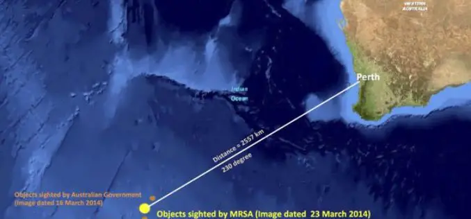
MRSA Satellite Image Analysis Show New Debris Field
In recent news, the images taken on March 23 by Airbus Defence and Space in France were analysed by the Malaysian Remote Sensing Agency, which was “able to identify 122 potential

exactEarth Release Tracking Data of the Search for MH370
Malaysia Airlines Flight MH370, which disappeared over two weeks ago en route to Beijing, appears to have crashed thousands of miles away in the southern Indian Ocean, exactEarth have released the
Microsoft Introduces New Oblique UltraCam Osprey
Baltimore, Maryland — March 25, 2013 — From the ASPRS conference in Baltimore, Maryland, Microsoft’s UltraCam business unit introduces the UltraCam Osprey, a new digital aerial system that combines a high

Supergeo Partners with GPS P.L to Offer iOS-powered Mobile GIS Turnkey Solution
GPS.PL has nearly 2 decades experience in the field of GNSS and INS, covering diverse areas like sea, air, farming, forestry, ecology, and defense, field survey, etc. The provision of
