
Archive
GPS Position Accuracy Measures By NovAtel
GPS Position Accuracy Measures Overview There are various statistical methods of describing specifications for GPS receiver and it can seem confusing or misleading the meaning of such statistics. The purpose

PPT-Aerial Imagery By David Davis, USDA Farm Service Agency, Aerial Photography Field Office
This PPt gives an historical and present overview of how Aerial Photogrammery has changed. Written by: David Davis, USDA Farm Service Agency, Aerial Photography Field Office Download PPT-Aerial Imagery By David Davis
Evaluation of Narrowband and Broadband Vegetation Indices for Determining Optimal Hyperspectral Wavebands for Agricultural Crop Characterization
Evaluation of Narrowband and Broadband Vegetation Indices for Determining Optimal Hyperspectral Wavebands for Agricultural Crop Characterization By: Prasad S. Thenkabail, Ronald B. Smith, and Eddy De Pauw Abstract: The main goal
PPT-Different Radiative Transfer Model
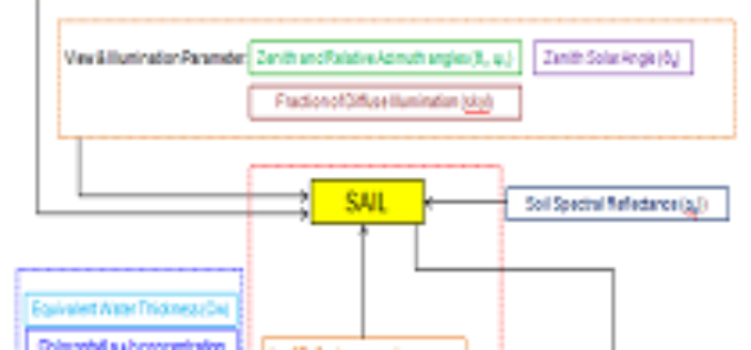
This PPT gives an insight to: What is Radiative Transfer Model? Different Types of RTM? What is PROSAIL? Inputs of PROSAIL. Retrieval of Biophysical Parameters using PROSAIL. Simulation of PROSAIL.
PPT – Various Change Detection Analysis Techniques
This PPT will give an overview of Various Change Detection Analysis Techniques. Download Various Change Detection Analysis Techniques.

Skills for the Digital Earth:The Use of Location Technologies for All
Skills for the Digital Earth: The Use of Location Technologies for All Massive open online course – March 30 – April 26, 2014 (4 weeks) Elmhurst College’s Skills for the Digital Earth

Spatial Business Systems Announces SpatialBiz Plug-in for FME 2014
Latest release provides rich new functions and improved performance for GE Smallworld users Lakewood, CO – Spatial Business Systems (SBS) announces immediate availability of the 2014 SpatialBiz Plug-in. The SpatialBiz Plug-in

Out-Of-This-World Satellite Images Help Monitor The Environment
The new Centre for Applied Earth Observation will use images from satellites, aircraft, and the International Space Station to monitor globally important environmental issues such as changes in forestry activity
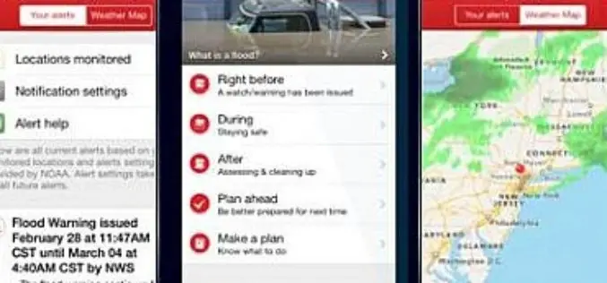
New Flood App Brings American Red Cross Safety Information to Mobile Devices
App’s audio flood and flash flood alerts can help save lives The American Red Cross today announced its new Flood App to help save lives and reduce losses from floods

NOAA and NASA Launch Coastal Vulnerability Innovation Challenge
Coastal communities are becoming increasingly vulnerable to the risk of damage from coastal inundation. We only have to remember the recent impact of Hurricane Sandy on communities in the northeast
