
Archive

Eyes in the Sky to Protect World Heritage Angkor Wat
As reported in Xinhua, China signed a MoU with HIST (UNESCO) to use remote sensing technology to provide a new level of protection for the ruins of Cambodia’s Angkor Wat, the
Modeling Glacier Elevation Change from Time Series DEM
Glaciers are always having an important impact on environment. Changing climate conditions have put a lot of pressure on our glaciers. Melting of glaciers could be very dangerous for life

Blue Marble Webcast: Attribute Management in Global Mapper
Blue Marble Webcasts: Attribute Management in Global Mapper August 25, 2015 No Registration Required Synonymous with the “I” in GIS, attribution is the data associated with features that are spatially
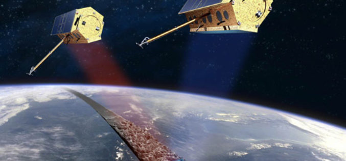
Free Provision of TerraSAR-X and TanDEM-X Data for Government Studies and Professional Training in Canada
Airbus Defence and Space has signed an agreement with the Canada Centre for Mapping and Earth Observation (CCMEO) providing Canadian governmental and institutional data users free access to TerraSAR-X and

Ceremonial and Historic County Boundary Data added to OS OpenData Portal
For 224 years Ordnance Survey (OS) has been mapping the changing physical landscape of Great Britain. However it is not only the landscape which has changed, Great Britain’s county boundaries have also changed
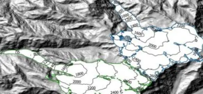
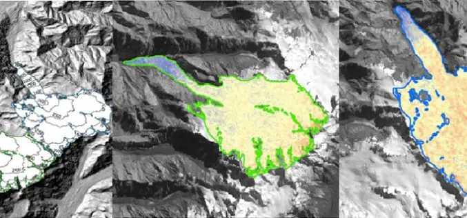
Modeling Glacier Elevation Change from DEM Time Series
Modeling Glacier Elevation Change from DEM Time Series – Wang, D.; Käb, A. Modeling Glacier Elevation Change from DEM Time Series. Remote Sens. 2015, 7, 10117-10142. Abstract: In this study, a methodology for

Rice Associates, Inc. Enters Drone World Through Partnership With Navigator CS, LLC
MANASSAS, VA – Rice Associates, Inc. and Navigator CS, LLC have announced the formation of a business partnership that will allow Rice Associates, Inc. to utilize Navigator’s Unmanned Aircraft Systems

GeoShot Technologies Completed Large City Modeling Project Using LiDAR Data
GeoShot Technologies has successfully completed large city modeling using LiDAR data. “We are very excited to complete the first large scale city modeling project at GeoShot Technologies at a time

SuperSurv 3.3 Brings Whole New Experience to Field Tasks
SuperSurv 3.3 for Android, the mobile survey GIS App developed by Supergeo, is now upgraded and released, with new and improved functions. The new SuperSurv 3.3 not only enables users
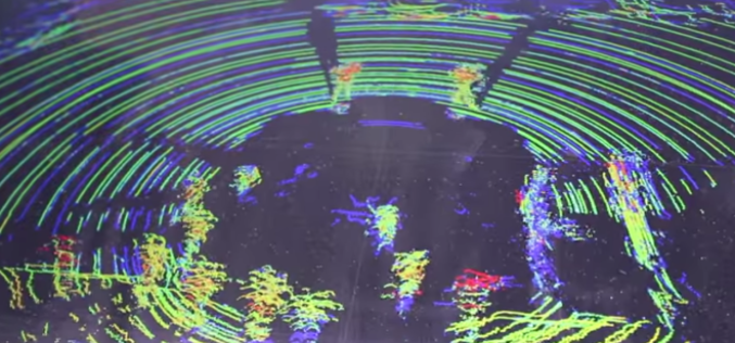
Implementing LiDAR Technology in Transportation System
Brian Davis a Research Fellow at University of Minnesota is working on LiDAR (light detection and ranging) technology for implementing in transportation systems. Davis and his fellow researchers have outfitted a
