
Archive
Call for State of the Map US 2016!
The call for locations for State of the Map US 2016 (when did it get to be 2016??!!) is open. Get your city ready to bring the OSM US community

Webinar on SAR Interferometry using SARScape tool for ArcGIS
Esri India Webinar on SAR Interferometry using SARScape tool for ArcGIS The use of Synthetic Aperture Radar (SAR) data has become increasingly popular in recent years, offering professionals in a

Jason-3 Successfully Launched
Vandenberg Air Force Base, California, 17 January 2016 – The Jason-3 high-precision ocean altimetry satellite was successfully launched from Vandenberg Air Force Base in California at 19:42 CET (10:42 California

NHAI Signs MoU with ISRO and NECTAR for Use of Spatial Technology for Monitoring and Managing National Highway
NHAI has signed Memorandum of Understanding with National Remote Sensing Centre (NRSC) under Indian Space Research Organization (ISRO) and North East Centre for Technology Application and Research (NECTAR) for use
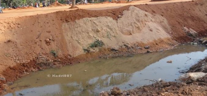
Saving India’s Vanishing Water Bodies
“GIS technology plays an important role in managing our natural and man-made water infrastructure, and is readily available”,The recent floods in Chennai have been largely blamed on water body encroachments.

Orbit rolls out GIS Mapping System for Housing Management
Orbit, which manages homes across the Midlands, East and South East, has rolled out a web-based GIS system for its 1,300 staff to access geographic information, maps and analysis to

Blue Marble Webinar: Working with Vector Data in Global Mapper
In mapping technology, vector data takes the form of points, lines, or polygons, with each variant distinguished by the geometric relationship of a series of x and y (and sometimes

Register Now for Esri UC 2016 and Receive $400 Off
ESRI UC 2016 – A Lot of Learning in One Location June 27-July 1, 2016 | San Diego, California Learn, network and share your experiences with 16,000 other Esri GIS

Find the Best Location – Boost Business with GIS Analysis
Find the Best Location – Boost Business with GIS Analysis Wednesday, 27th January 09:00 AM (GMT) Your Local Time (http://goo.gl/y6KG0H) Sales reports, buyer behaviors, public transportation and etc., you got

PCI Geomatics to Hold User Group Meeting in Ottawa, Canada
PCI Geomatics, a world leading developer of remote sensing and photogrammetric software and systems, will be holding a User Group Meeting in Ottawa, Canada on February 4th, 2016. The free
