
Archive
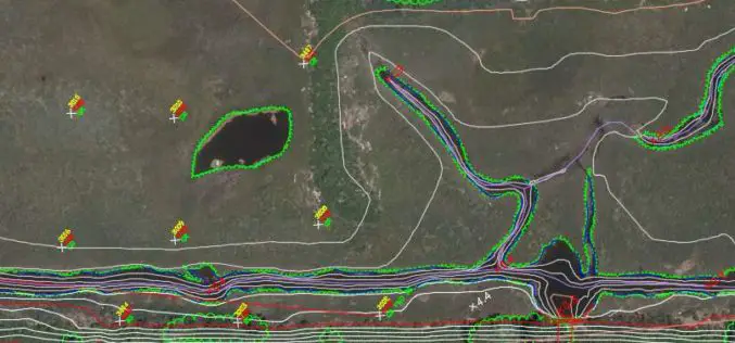
Col-East Taps Extensive Image Archive to Create Multi-Function Maps
NORTH ADAMS, Massachusetts, 4 October 2017 – Col-East International Ltd., a provider of aerial photogrammetric services in the Northeast U.S. since 1952, tapped into its extensive archive of aerial imagery

GeoSLAM and Bentley Systems Join Forces to Take Mobile Reality Modelling Indoors
BENTLEY YII 2017, SINGAPORE, OCTOBER 5, 2017 – GeoSLAM – the experts in “go anywhere” 3D mobile mapping technology, and Bentley Systems, a leading global provider of comprehensive software solutions for advancing infrastructure,

SimActive Announce the Release of Correlator3D™ version 7.0
SimActive Inc., is pleased to announce the release of Correlator3D™ version 7.0, with complete redesign of its 3D generation engine enabling substantial quality and speed improvements. Version 7.0 also includes

National Highways Authority of India Launches GIS Enabled Website and Mobile App to Monitor Highways
New Delhi – According to recent news by the ToI, the National Highways Authority of India (NHAI) launches a mobile application that will allow passengers to rate the national highways across the

Vexcel Imaging Introduces UltraCam Eagle Mark 3: Wider Swath Width for Increased Efficiency
Graz, Austria – October 03, 2017 – At the Intergeo 2017 conference in Berlin, Vexcel Imaging introduced the newest model of its widely adopted UltraCam digital aerial camera systems, the UltraCam Eagle

OGC Has Approved the New 3D Portrayal Service Standard
October 4, 2017 – The membership of the Open Geospatial Consortium (OGC®) has approved the 3D Portrayal Service (3DPS) 1.0 standard. Viewing 3D geospatial content from diverse sources has just become

Goa-based Transerve Technologies Raises $1.6mn Funds
Panji, Goa – According to recent news by the TOI and SMEPost.com, Goa-based Transerve Technologies, a company that offers geospatial technology-based SaaS solutions for sustainable growth and urban planning, has raised
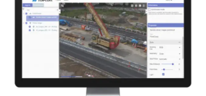
Topcon Announces New Web-Based Service for Mass Data Processing Software
LIVERMORE, Calif., U.S./ CAPELLE A/D IJSSEL, the Netherlands – September 26, 2017 – Topcon Positioning Group announces a new web-based service for integration with the MAGNET® Collage desktop mass data processing

OSGeo Signs MoU with U.S. Department of Interior
Osaka, Japan, 29 September 2017: The Open Source Geospatial Foundation has signed a Memorandum of Understanding with the United States Department of Interior (DOI). The agreement enables both organizations to
