
Archive
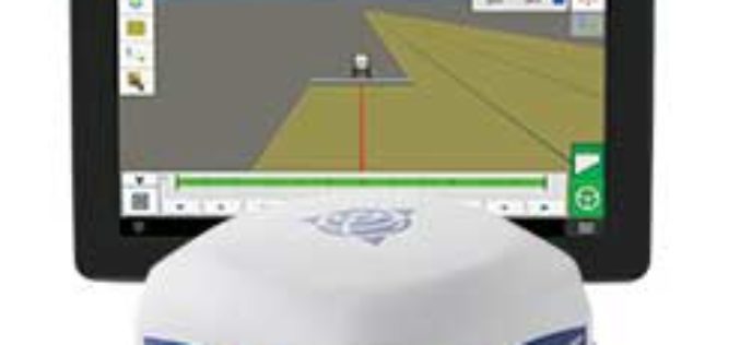
Trimble Introduces ISOBUS-Compatible GFX-750 Display System with Advanced Guidance Controller for Agriculture Applications
Enhanced Connectivity with Integrated Wi-Fi and Bluetooth Communications SUNNYVALE, Calif., Oct. 30, 2017—Trimble (NASDAQ: TRMB) introduced today the Trimble® GFX-750™ display system for agriculture applications. The display system comes with

SimActive Automates Direct Georeferencing
October 31, 2017 – SimActive is pleased to announce an automated solution for direct georeferencing from real-time kinematic (RTK) positioning. Within the new workflow feature, users can easily get high accuracy

Fund of Rs 14,124 crore for 8 Smart Cities in Northeast
According to recent news reported by The Indian Express, the Central Government of India has approved funds to the of Rs 14,124 crore for 464 projects in eight cities in
Storm Water Modeling and Flood Disaster Management Using Open Source Software
Contributed by: Geospatial data serves as an input in hydraulic simulation software and thereby the simulated results can further be transferred back to GIS system for real-world graphical representation of

GRACE Mission Comes to an End after 15 years of Successful Operation
Measuring gravitational changes and precisely documenting climate change End of the over 15 years German-US scientific mission GRACE designed to accurately measure Earth’s gravity field Since their launch on 17
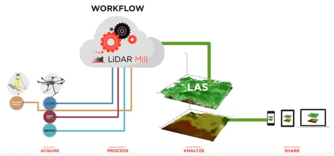
Phoenix LiDAR Unveils LiDAR Mill, the First Cloud-Based Post-Processing Platform
Cloud-based LiDAR platform automates trajectory processing, making the technology more affordable and accessible LOS ANGELES, CA (PRWEB) OCTOBER 26, 2017 – Addressing a major opportunity in the LiDAR industry, Phoenix LiDAR Systems

Velodyne LiDAR Partners with YellowScan for Integrated LiDAR for UAVs
YellowScan to leverage Velodyne’s lightweight VLP-16 Puck LiDAR sensors for its advanced aerial Surveyor LiDAR system October 26, 2017 – SAN JOSE, Calif.–(BUSINESS WIRE)–Velodyne LiDAR Inc., the world leader in 3D
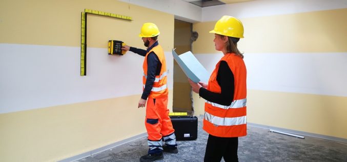
IDS GeoRadar Unveils Ground Penetrating Radar to Improve Safety Before Cutting or Drilling into Concrete Structures
C-thrue is an all-in-one, robust solution to see through concrete structures and reveal true data October 24, 2017 – Pisa, Italy: IDS GeoRadar, a leading provider of multi-frequency, multi-channel Ground Penetrating

Kongsberg Geospatial Collaborating with Wind River for Safety-Critical Geospatial Applications
October 24, 2017 – Ottawa, CA: Kongsberg Geospatial, an Ottawa-based developer of geospatial software technology, announced today that they are collaborating with Wind River® to validate their safety-critical geospatial components for

4DMapper Incorporates Global Mapper SDK Enabling Cloud Based Geospatial Analytics
Hallowell, Maine – October 23, 2017 – Blue Marble Geographics (bluemarblegeo.com) is pleased to announce that 4DMapper (4dmapper.com), a geospatial technology company based in Australia, has chosen the Global Mapper Software
