
Archive
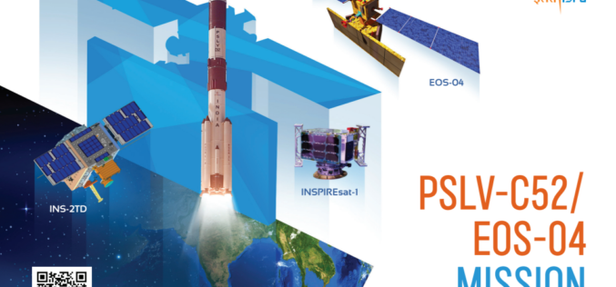
ISRO’s First Launch of the Year 2022, PSLV-C52 successfully launches EOS-04 and other 2 Satellites
On Valentine’s day, ISRO has given a gift to the nation with the successful launch of the Polar Satellite Launch Vehicle PSLV- C52 successfully launched EOS-04 Satellite from the first
RMSI Develops Award-Winning Land Record Information Management System for the Department of Land Management and Archive (DOLMA), Nepal
RMSI, a global leader in geospatial and engineering solutions, was commissioned by The Department of Land Management and Archive (DOLMA), Nepal, to deliver a web-based solution, Land Record Information Management
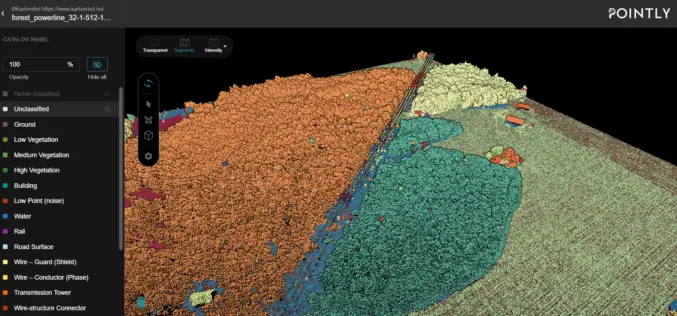
Automated Point Cloud Analysis for Forestry Mapping
Pointly has developed AI solution, that takes point clouds as input and outputs a shapefile with the location of tress for forestry mapping.

Applanix Introduces Next-Generation OEM Solution for Mobile Mapping Applications Using GNSS-Inertial Technology
Hardware and Software Platform Provides Unparalleled Accuracy and Performance for Systems Integrators Applanix, a Trimble Company (NASDAQ: TRMB), announced today the Trimble® AP+ Land GNSS-inertial OEM solution for accurate and

Master Basic Math Skills With the Help of Online Math Tutors
Increase Your Confidence With the Help of Online Math Tutors There’s no getting around it—math is a difficult subject for many people. Those who never had the chance to master
