• Aims to foster innovation for its brand-new laser-based space communication system.
• Winner will be awarded €75,000 investment and will get support of Airbus BizLab.
 12
12
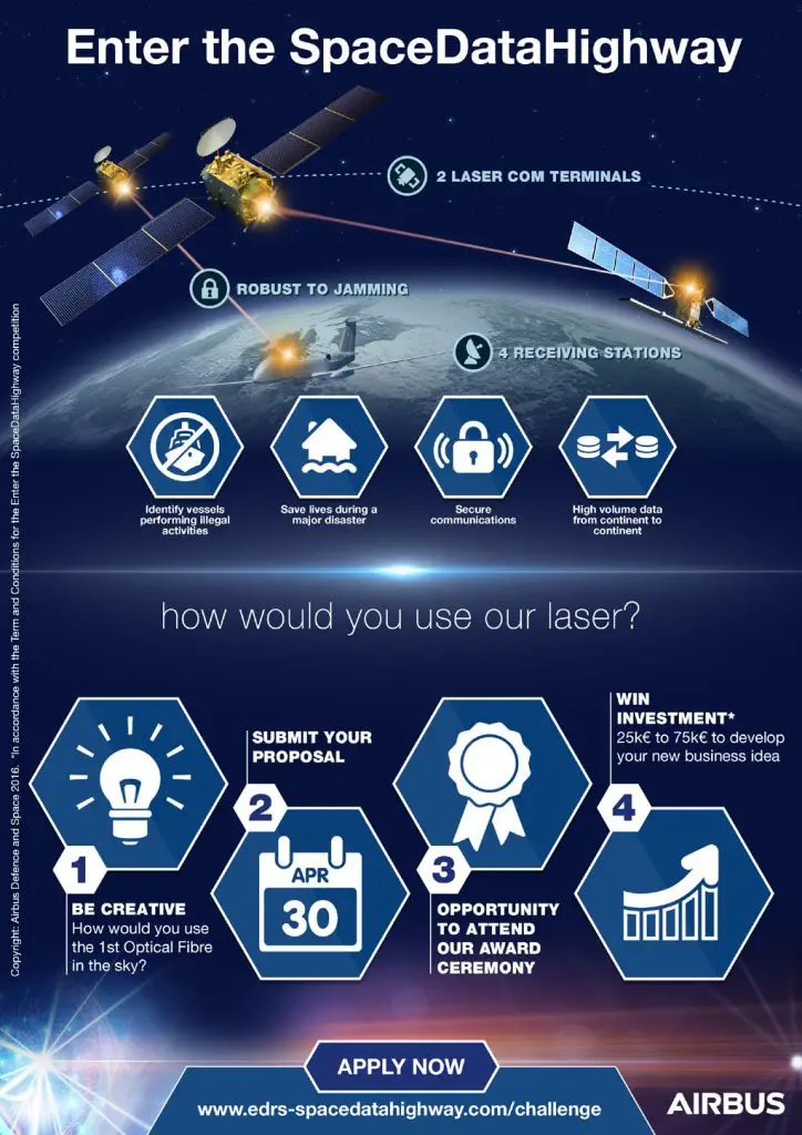
The winning project will receive a prize in the form of a € 75,000 investment, and will be able to draw on the expertise and support of Airbus Bizlab, the Group’s innovation powerhouse. Airbus Bizlab is a business incubator in which entrepreneurs or start-ups participate in a six-month programme. They will be accompanied by engineers, business development experts or even by coaches to support them in the realisation of prototypes, market studies or the launch of a product. The project that comes second will receive a prize of € 25,000 to launch a crowdfunding campaign on the brand-new SpaceStarters platform which enables space related businesses and start-ups to raise money in order to turn their innovative ideas into business reality.
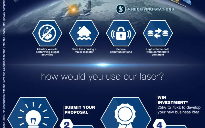
The SpaceDataHighway is a unique space communication system combining ultra-broadband laser communications in geostationary orbit to deliver a unique, secure, near real time data transfer service – making data latency a thing of the past. It can help revolutionise a number of areas, including the handling of humanitarian crises, maritime security and environmental protection by receiving satellite imagery in near real time. The Sentinel satellites of the European Union’s Earth observation programme Copernicus will be the first to benefit from these next-generation services. However, the SpaceDataHighway will also be able to connect other platforms such as aircraft, UAVs or the International Space Station.
“In general, space communications are the only way to establish broadband communications between humans and machines, whether they are in urban or remote areas, at sea, in the air or even in space. The SpaceDataHighway is like the first optical fiber in space, but with the added advantage of mobility. Therefore, the scope of possible applications is vast”, said Hughes Boulnois, head of the SpaceDataHighway business at Airbus Defence and Space. “With the generalisation of space technologies and the emergence of new stakeholders in the sector, Airbus wants this initiative to engage with and listen to the end-users market needs and to develop ideas to support this extended space ecosystem.”
This initiative has been launched with the support of the European Commission and the European Space Agency, which, together with Airbus, developed the SpaceDataHighway programme as part of a public–private partnership. To take part in the “Enter the SpaceDataHighway” challenge, visit: http://www.edrs-spacedatahighway.com/challenge.
About Airbus
Airbus is a global leader in aeronautics, space and related services. In 2015, it generated revenues of €64.5 billion and employed a workforce of around 136,600. Airbus offers the most comprehensive range of passenger airliners from 100 to more than 600 seats. Airbus is also a European leader providing tanker, combat, transport and mission aircraft, as well as Europe’s number one space enterprise and the world’s second largest space business. In helicopters, Airbus provides the most efficient civil and military rotorcraft solutions worldwide.
More about Space Data Highway: http://bit.ly/2fvwttP
More about the challenge: http://bit.ly/2ifU4VB