
Posts From GIS Resources
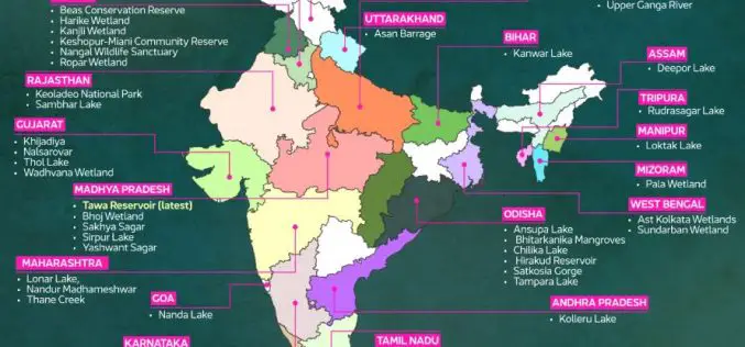
Tamil Nadu Uses GIS to Protect Ramsar Sites
Tamil Nadu is embracing advanced technology to safeguard its Ramsar sites, wetlands of global ecological importance. The Tamil Nadu Wetland Authority plans to utilize drones, machine learning, and GIS to
Topcon Announces Landmark Expansion of Topnet Live Network Across USA
Topcon Positioning Systems has announced a significant expansion of its Topnet Live reference station network, introducing 200 new geodetic stations strategically positioned across the United States. This comprehensive network upgrade expands the availability

EagleView Launches New Property Data Ecosystem
EagleView, a leading provider of aerial imagery, announces the launch of its new property data ecosystem. The ecosystem has over 60 petabytes of asset data derived from high-definition aerial imagery.

Indian Army Introduces GIS-Powered Battlefield System
The Indian Army is set to revolutionize its operational capabilities with the introduction of the Battlefield Surveillance System (BSS), a sophisticated platform that integrates data from various sensors to enhance

Remote Sensing Archaeology Locates Ancient Valabhi Town in Gujarat
A groundbreaking study has utilized remote sensing archaeology to uncover the location of the ancient town of Valabhi in Gujarat, India. Valabhi, once the thriving administrative capital of the Maitraka

RMIT Australia Partners with India for GPS Alternative Development
RMIT University is collaborating with Indian microchip manufacturers and Australian air traffic management company Skykraft to develop an alternative to the U.S.-owned Global Positioning System (GPS). This initiative is supported

USGS Unveils First Map of Geologic Hydrogen in the U.S.
The U.S. Geological Survey (USGS) has released a groundbreaking map highlighting potential regions for Geologic Hydrogen in the contiguous United States. This innovative tool represents a significant step forward in

PRSC-EO1: Pakistan’s First Indigenous Electro-Optical Satellite Launched
Pakistan has achieved a significant milestone with the successful launch of its first indigenous Electro-Optical satellite, PRSC-EO1. The satellite was launched on January 17, 2025, from China’s Jiuquan Satellite Launch

Pixxel Launches World’s Highest-Resolution Hyperspectral Satellites for Climate Action
Pixxel, a California-based space technology company building the world’s highest-resolution hyperspectral satellite constellation, successfully launched the first three satellites of its Firefly constellation on January 15, 2025. The satellites were

Laos Embraces Satellite Technology for Carbon Credit Feasibility
Laos is taking significant steps towards sustainable development by leveraging satellite remote sensing to evaluate carbon stocks across nine forest areas, covering 170,556 hectares. This initiative, led by the Ministry
