
Posts From GIS Resources

PCI Geomatics Releases Linux Versions of Geomatica 2014
RICHMOND HILL, Ontario, Canada—August 7, 2014: PCI Geomatics, a world leading developer of geo-imaging software and systems, today announces the release of three Linux versions of Geomatica 2014, the latest

China Successfully Launches Remote Sensing Satellite
BEIJING: China today successfully launched a remote-sensing satellite to carry out scientific experiments and provide early alerts about natural disasters. The Yaogan XX satellite blasted off at 1:45 pm local time on the back of a Long

RFP: Preparation of GIS Base Map and Conducting Multi Purpose Household Surveys with Technical Handholding Support in 67Cities
Directorate, Urban Administration & Development Government of Madhya Pradesh (GoMP) Request for Proposals for Short listing of Agencies for GIS-based Property Tax Reform which includes Preparation of GIS Base Map

OGC Publishes Tested 10 Open Mobility Location Standards Engineering Reports
19 public Engineering Reports resulted from the Open Geospatial Consortium’s (OGC®) OGC Testbed 10, the most recent in the OGC’s yearly series of major geospatial interoperability testbeds. Six of these reports

Google Polluted Internet With Classified Material: Survey of India
NEW DELHI: After registering a Preliminary Enquiry against Google for alleged mapping of classified areas, the CBI has sought help of the Survey of India (SoI) which has alleged that
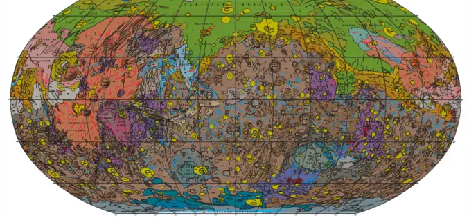
Geologic Map of Mars
Geologic Map of Mars Abstract This global geologic map of Mars, which records the distribution of geologic units and landforms on the planet’s surface through time, is based on unprecedented

Webinar: Smart City Solutions with Interactive 3D GIS Technologies
Smart City Solutions with Interactive 3D GIS Technologies Feeling not enough about traditional 2D maps? With SuperGIS 3D Earth Server, you can see different features and explore spatial relations on
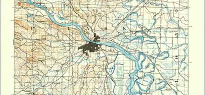
Revised Arkansas and South Carolina Maps Feature New Design
Newly designed US Topo maps covering Arkansas and South Carolina are now available online for free download US Topo maps now have a crisper, cleaner design – enhancing readability of maps

New Automated Stockpile Volume Solution Launches
3D Laser Mapping Brings Fast, Cost Effective Automated Volume Measurement To The Mining Industry 3D Laser Mapping has announced SiteMonitorSV as the latest offering from its suite of SiteMonitor solutions.

Institute of Forest Genetics and Tree Breeding to Map Trees in Tamil Nadu using GIS
In recent news, the Institute of Forest Genetics and Tree Breeding (IFGTB) is going to do Geographical Information System (GIS) based mapping of tress in all 32 districts of Tamil
