
Courses
Call for Applications for the Ph.D. Programme by ESSO-INCOIS
ESSO-INCOIS is a leading institute in the field of operational Oceanography with a specific objective to provide oceanographic information and advisories to public. The services of ESSO-INCOIS are supported by focused in-house
URISA Connect Webinars & Virtual Education
URISA Connect is the virtual component of URISA’s educational offerings. Webinars that connect you to the cutting edge in technology and management lessons for the GIS industry are at your
INCOIS: International Training Course On”Ocean Colour Remote Sensing – Data, Processing and Applications”
International Training Course On “Ocean Colour Remote Sensing – Data, Processing and Applications” Organized by International Training Centre for Operational Oceanography (ITCOcean) ESSO-INCOIS, Hyderabad, India November 10-14, 2014 Indian National Center for Ocean Information Service (INCOIS) under earth System Science organization (ESSO) is a dedicated institution for operational oceanography and the

PhD Position @ Utrecht University – Canopy Nitrogen Mapping using Remote Sensing
PhD Researcher: Canopy Nitrogen Mapping using Remote Sensing (1.0 fte) Utrecht University is a university in Utrecht, the Netherlands. It is one of the oldest universities in the Netherlands and one of
University of Oslo: PhD Research Fellow in Remote Sensing and Photogrammetry
The University of Oslo is Norway’s largest institution of research and education with 28 000 students and 7000 employees. Its broad range of academic disciplines and internationally esteemed research communities

University of Glasgow Offering MSc/PgCert/PgDip Course in Geospatial and Mapping Sciences
Founded in 1451, Glasgow is the fourth-oldest university in the English-speaking world. Over the last five centuries and more, we’ve constantly worked to push the boundaries of what’s possible. We’ve fostered
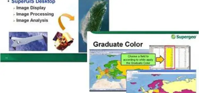
Supergeo to Provide Free Online GIS Web Courses
To well promote GIS technologies in real case application, Supergeo is going to provide free online GIS web courses. From basic to advanced, the courses will introduce GIS software on
York University Offering Certificate Courses in Remote Sensing
York University is helping to shape the global thinkers and thinking that will define tomorrow. York is Canada’s third largest university with a commitment to excellence which reflects a rich

University of North Alabama Offers Online GIS Analyst Certificate Program
University of North Alabama Offers Online GIS Analyst Certificate Program consisting of five courses that will be completed in 9 months (September 16, 2014 – May 28, 2015). The five courses
University of Hawaii Offers Certificate Course in GIS
The University of Hawaii is now offering a Certificate of Competence in Geographic Information Systems (GIS)! The course is offered on Maui, Kauai, and Hawaii Island campuses. The course is part of
