
GIS

New Esri Book Proposes Changes to US Land Records System
Modernizing American Land Records: Order upon Chaos Provides a Comprehensive View of the System’s Problems and Possible Solutions Redlands, California—Modernizing American Land Records: Order upon Chaos examines the history of American

Hong Kong Polytechnic University Empowers GIS Analyst with SuperGIS Desktop
Supergeo Technologies, the leading global provider of GIS software and solutions, announces that Hong Kong Polytechnic University (HKPU) selects SuperGIS Desktop through Star Vision, Supergeo certified reseller, to educate the

Noida to be Mapped in 3D
In recent news, the Noida Authority is getting set to create a 3D model of the city. This will be first city in Uttar Pradesh to be mapped in 3D.

Google Mapping Comes Under CBI Scrutiny
CBI has registered a preliminary enquiry (PE) against internet giant Google over Mapathon 2013, an event organised by the U.S. company, for allegedly violating laws by mapping sensitive areas and
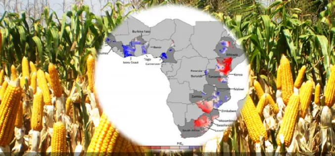
Water, Water — Not Everywhere: Mapping Water Trends for African Maize
Today’s food production relies heavily on irrigation, but across sub-Saharan Africa only 4 percent of cultivated land is irrigated, compared with a global average of 18 percent. Small-scale farming is
SuperSurv 3.2 Beta Launched for Intuitive GIS Data Capture
Supergeo launched SuperSurv 3.2 (Android) Beta for global users. The new app will possess more practical functions, enhance user interface and improve query and way point efficiency, providing users with
Supergeo Invest in Innovative Geographic Network Analysis for Next Generation GIS Products
Supergeo Technologies, a leading global provider of GIS software and solutions, announces the investment plan in advanced geographic network applications. The technology collaboration is conducted by Supergeo and the Department

The Geographic Calculator 2014, SP1 Now Available with New Jobs to Streamline Workflow
Hallowell, Maine – July 22, 2014 – Blue Marble Geographics (bluemarblegeo.com) is pleased to announce the release of the Geographic Calculator 2014 Service Pack 1 (SP1). This interim release features new
Esri and European Schoolnet Partner to Deliver Geographic Education Internationally
More Than 30 Ministries of Education to Gain Access to ArcGIS Online Redlands, California—School systems across Europe will soon have access to the world’s leading online mapping software for delivering

China Distributes Millions of Controversial Maps to Troops
Beijing: China is distributing millions of controversial updated maps to its military in the first upgrade in 30 years, reportedly reinforcing its claims over Arunachal Pradesh. All major army units will
