
GIS

Government Sanctions Rs. 10 Crore for Mapping Accident Maps
The Union Minister for Road Transport and Highways Nitin Gadkari has said the government has sanctioned Rs 10 crore to Central Road Research Institute (CRRI) for locating regular accident prone

CIDCO to Sign MoU to Construct Palghar’s infrastructure
Thane, Mumbai: City and Industrial Development Corporation (CIDCO) Vice Chairman and Managing Director Sanjay Bhatia said here today that the state-owned corporation plans to sign an MoU to construct infrastructure
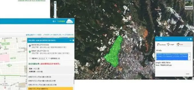
Brain of Smart City: A GIS Platform for Sharing 2D and 3D Maps
Smart City, defined as utilizing digital technologies to trim costs and resource consumption to engage its citizens more effectively in various domains like transport, health care, energy, water, and so

Alur Seelin Kiran Kumar Takes Over as Space Secretary
Distinguished space scientist Alur Seelin Kiran Kumar took over as secretary of the department of space and chairman of the Space Commission and the state-run ISRO here. Prior to his appointment to

PCI Geomatics announces strategic partnership with MDA for Accessing RADARSAT-2 Imagery
PCI Geomatics, a world leading developer of remote sensing and photogrammetric software and systems, announced today a strategic partnership with McDonald, Dettwiler and Associated Ltd. (MDA). The partnership introduces a solution that
New Nebraska Maps Feature Trails
Newly released US Topo maps for Nebraska now feature trails provided to the USGS through a “crowdsourcing” project operated by the International Mountain Biking Association (IMBA). Several of the 1,376

US Army Corps of Engineers Selects SimActive for Drones
SimActive Inc., a world-leading developer of photogrammetry software, has been selected by the United States Army Corps of Engineers (USACE). They join professionals across the globe using Correlator3D™ with UAV

W3C and OGC to Collaborate to Integrate Spatial Data on the Web
6 January 2015 — The W3C and the Open Geospatial Consortium (OGC) announced today a new collaboration to improve interoperability and integration of spatial data on the Web. Spatial data

EUROGEO Conference on Communicating Geography: serving our world
Communicating Geography: serving our world 21-22 May 2015, Ankara, Turkey About Ankara Although it was a small town before the proclamation of the republic in the early 1900s, Ankara today

SuperGIS Cache Generator Now Supports STP Format
Supergeo announces that Cache Generator, the built-in tool in SuperGIS Desktop 3.2, now supports STP format, as a faster alternative to STC and XML files, for users to experience a
