
GIS
Discover Top 10 GIS Features with Latest SuperGIS Desktop
To make GIS software friendlier and easier to access, Supergeo, the leading GIS software provider, collects GIS users’ ideas around the world, and votes the 10 most useful features of
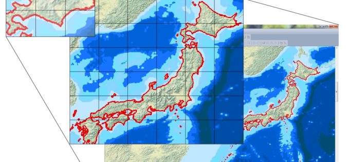
More Global Topographic Data to Aid Climate Change Research
Enhanced elevation data for most of Asia and Oceania; third of four releases Improved global topographic (elevation) data are now publicly available for most of Asia (India, China, southern Siberia,

Ordnance Survey Set to Become a Government-Owned Company
Proposals for converting Ordnance Survey from a Trading Fund into a government-owned company have today moved a step closer 22 January 2015 – As announced this morning in a Written Ministerial

Blue Marble to Highlight Use of Global Mapper for the Military
Blue Marble Geographics (bluemarblegeo.com) will be exhibiting at the 26th Annual SO/LIC Symposium & Exhibition held in Washington, D.C. at the Washington Marriott Wardman Park Hotel on January 26-28, 2015.

Google to End Support for Google Maps Engine
In an official Google user group, it has been informed that Google will end support for the Google Maps Engine. Google will provide support for the Google Maps Engine (GME) product
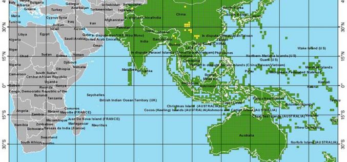
Esri Releases Demographic Data for 137 Countries
Global Income, Population and Business Data Now Easily Available for Better Local Market Knowledge Esri announces that geodemographic information for 57 additional countries has been added to its ready-to-use ArcGIS

OGC Adopts IndoorGML Standard for Encoding Indoor Navigation Data
The Open Geospatial Consortium (OGC) membership has approved the OGC IndoorGML Encoding Standard. This OGC standard specifies an open abstract data model and XML schema for indoor spatial information. The

W3C and OGC to Collaborate to Integrate Spatial Data on the Web
The W3C and the Open Geospatial Consortium (OGC) announced today a new collaboration to improve interoperability and integration of spatial data on the Web. Spatial data —describing geographic locations on

Pakistan to Introduce Smart Phones for Digital Mapping of Dengue
According to recent news, Dengue Prevention and Control Programme (DPCP) Sindh (Pakistan) to introduce smart phones for digital mapping of high-risk areas of dengue larva breeding points, patients and

Central Silk Board Using GIS for Potential Areas for Sericulture Expansion
India- the Central Silk Board under the Ministry of Textile has taken up a project to identify potential areas for sericulture expansion using GIS and remote sensing technology. The project
