
Business

SuperSurv 3.2 Beta Launched for Intuitive GIS Data Capture
Supergeo launched SuperSurv 3.2 (Android) Beta for global users. The new app will possess more practical functions, enhance user interface and improve query and way point efficiency, providing users with
Supergeo Invest in Innovative Geographic Network Analysis for Next Generation GIS Products
Supergeo Technologies, a leading global provider of GIS software and solutions, announces the investment plan in advanced geographic network applications. The technology collaboration is conducted by Supergeo and the Department

The Geographic Calculator 2014, SP1 Now Available with New Jobs to Streamline Workflow
Hallowell, Maine – July 22, 2014 – Blue Marble Geographics (bluemarblegeo.com) is pleased to announce the release of the Geographic Calculator 2014 Service Pack 1 (SP1). This interim release features new

Esri and European Schoolnet Partner to Deliver Geographic Education Internationally
More Than 30 Ministries of Education to Gain Access to ArcGIS Online Redlands, California—School systems across Europe will soon have access to the world’s leading online mapping software for delivering

Ordnance Survey Innovation Team Supports Young Programmers in Annual Festival of Code
Young people from across the Solent area, with a keen eye for coding are being urged to sign up to a national coding competition this summer between 28 July and
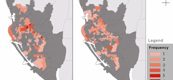
Dengue Fever Control and Prevention via GIS Technologies
Controlling and preventing infectious diseases like dengue fever is one of the main issues for public health authorities in many countries. GIS technologies can play a key role to support

New Global Geologic Map of Mars
Understanding the Past to Enable Future Exploration A new global geologic map of Mars –the most thorough representation of the “Red Planet’s” surface – has been published by the U.S.

Icaros to Unveil Oblique Image Viewer and Measuring Tool for ArcGIS
FAIRFAX, Virginia, USA, – Icaros Inc. (Icaros), a leading provider of advanced aerial remote sensing and 3D visualization solutions, will introduce the Icaros Measurement Tool (IMT), a simple but powerful

Avenza Releases MAPublisher 9.5 for Adobe Illustrator
Cartographic add-on now compatible with Adobe Illustrator Creative Cloud™ 2014 Toronto, ON, July 9, 2014 – Avenza Systems Inc., producers of the PDF Maps app for mobile and geospatial plug-ins
Blue Marble Exhibits in South Africa
Hallowell, Maine – July 8, 2014 – Representatives from Blue Marble Geographics (bluemarblegeo.com) have just returned from a very successful and exciting trip to Cape Town, South Africa. The trip to
