
Business

SimActive Introduces New Technology for True Orthos
November 28, 2017 – SimActive Inc., a world-leading developer of photogrammetry software, is pleased to announce Correlator3D™ version 7.1 with revolutionary technology for true orthos. Users can now automatically generate enhanced

Microsoft launches Azure Location Based Services for Geospatial Needs Across Industries
Together with an ecosystem of partners, Microsoft’s cloud offers enterprise customers choice and options for using location data to solve issues such as asset location tracking, fleet management and traffic congestion. REDMOND,
Create Photogrammetric Point Cloud Using Global Mapper Pixels-to-Points Tool
Global Mapper LiDAR Module v.19 Now Available with Pixels-to-Points™ Tool for Photogrammetric Point Cloud Creation November 29, 2017 – Blue Marble Geographics is pleased to announce the release of version 19 of the

Presagis Introduces New Automated Virtual Environment Production Solution
November 27 2017 – Montreal, Canada – Presagis™, a recognized leader in modeling and simulation software, today introduced VELOCITY, a next-generation software solution that automates the production of large synthetic training

uAvionix, Leader in Drone Communications, Navigation, and Surveillance Systems, Secures Series B Funding from Airbus Ventures, Playground Global, and Redpoint Ventures
The investment reinforces uAvionix’s mission to enable airspace awareness through high integrity aviation solutions for both manned and unmanned aircraft. Bigfork, MT, November 27, 2017 – uAvionix Corporation – a leading
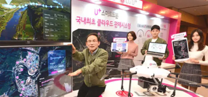
Terra Drone And LG U+ Put UTM System Into Commercial Use For The First Time In South Korea
November 27, 2017 – Terra Drone Co., Ltd., the leading Japanese commercial drone service company, has commercialized UTM(Unmanned Traffic Management)system for the first time in Korea collaborating with LG U+, a
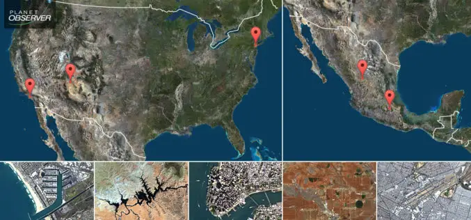
PlanetObserver Presents New PlanetSAT Updates Imagery Basemap of the United States and Mexico
Clermont-Ferrand, France – April 26th 2017 – The French company PlanetObserver, specialized in geospatial data production, has just finalized the new PlanetSAT Updates imagery basemap of the United States and
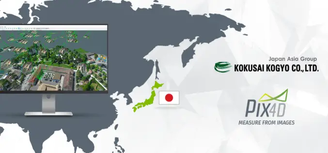
Pix4D Partners with Kokusai Kogyo in Japan to Deliver a 3D Geospatial Analysis Cloud Service
Full automation for 3D spatial analysis that support i-Construction and public surveying November 20, 2017 – Pix4D is partnering with Kokusai Kogyo Corporation (KKC)—the leading geospatial consulting company in Japan–to deliver

Supergeo Partners with Agricultural Engineering Research Center to Develop Irrigation Solution
Supergeo is excited to announce that Agricultural Engineering Research Center (AERC), the leading research institute in irrigation study, has collaborated with Supergeo to develop an irrigation solution based on SuperGIS

Building a Unique GIS Website without Coding by Brand New SuperGIS Server 10
Supergeo, the global leading GIS software provider, is glad to announce its brand-new GIS server software, SuperGIS Server 10, is expected to be launched in the mid-November! Inheriting the high
