
Business
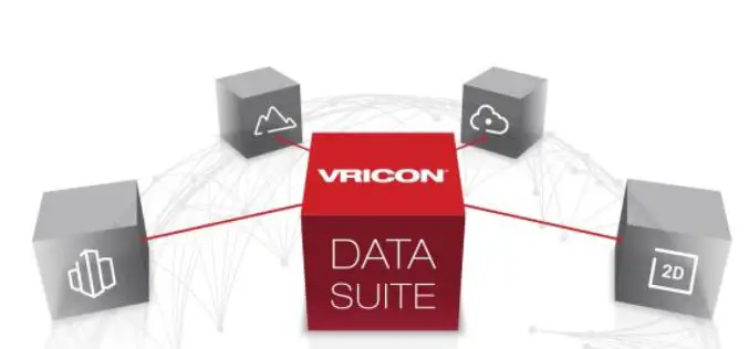
Vricon Data Suite: Putting Earth in Customers’ Hands
7 January 2016 — Today, Vricon unveils its Data Suite that includes the Vricon 3D Surface Model, Vricon DSM, Vricon Point Cloud, and Vricon True Ortho. All four products are

Hexagon Geospatial Launches IGNITE – M.App of the Future Challenge
Competition to Award $260,000 for Hexagon Smart M.App® Innovations NORCROSS, Ga., and LOS ANGELES, January 5, 2016 — Hexagon Geospatial today announced IGNITE — a first of its kind competition

Harris Corporation Collaborates with Boundless for Open-Source Geospatial
MELBOURNE, Florida, January 7, 2016 — Harris Corporation (NYSE:HRS) has expanded a collaboration with Boundless to further extend its capabilities in open-source geospatial technology. This partnership makes it easier and
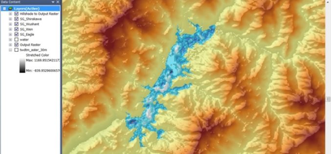
DAT/EM Systems International Releases 7.2
Anchorage, Alaska, USA. January 5, 2016 – DAT/EM Systems International® released the 7.2 edition of DAT/EM software products including Summit Evolution™, LandScape™, Capture™, MapEditor™, Ortho+Mosaic™, Airfield3D™ and Contour Creator™. The

OGC Announces New Arctic Spatial Data Infrastructure Project
The Open Geospatial Consortium (OGC®) announces a new OGC Interoperability Program project called the “Arctic Spatial Data Infrastructure Standards and Communication Pilot” (Arctic SDI Pilot). The Arctic SDI Pilot is
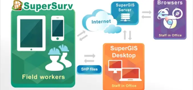
Romanian Surveying Company Selects SuperSurv
With assistance from Helix SRL, Supergeo’s partner in Italy, the Romanian company Black Light SRL has recently selected the well-known mobile GIS software SuperSurv as its mobile geospatial solution. Established
New Release of SuperGIS Server 3.2
Supergeo is proud to announce that the latest version of SuperGIS Server 3.2 is now available on our official website. This release includes some new features as well as improvements
GRASS GIS 7.0.3RC1 Released
The new GRASS GIS 7.0.3RC1 release provides 160 stability fixes and manual improvements. Of particular interest is the new winGRASS 64 bit support. About GRASS GIS 7: Its graphical user interface supports
Badger State Maps Put TIGER in the Tank
The USGS US Topo map program has entered its third, three-year cycle of revising and updating the digital US Topo maps. To start this new cycle, the USGS National Geospatial
Nepali Infrastructure Firm Chooses SuperGIS Desktop Professional
With the collaboration of Indian geospatial professional company, Satpalda Geospatial Services, the Nepali infrastructure firm in Kathmandu, Evernal Infrastructure Ltd., has selected SuperGIS Desktop 3.3 Professional and relevant extensions for
