Esri Showcases Smarter Decision Making through GIS at White House Water Summit
![]() Image: Esri
Image: Esri
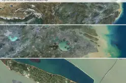
Esri is participating in the White House Water Summit, in celebration of the United Nations’ World Water Day. Esri has committed to building new technology that maps the extent and depth of flood forecasts, along with Kisters, a multinational IT company and Esri partner; the National Oceanic and Atmospheric Administration (NOAA); and members of the academic community. These forecasts will be made easily accessible through interactive web map applications that can be used by anyone to visualize when, where, and how deep a flood will be.
Esri will develop data processing and spatial analysis workflows for both stream flow and flood inundation forecasting. Local governments, first responders, citizens, and innovative startups will all find the information useful. This commitment builds on and expands work already in progress including the National Flood Interoperability Experiment and the National Water Model of the United States.
“The ability to forecast precipitation, stream flow, and flooding has significantly improved in recent years, as has the ability to convey sophisticated science to a broader community through web applications,” says Steve Kopp, software program manager at Esri.
These forecasts can be combined with other data to identify populations at risk and be a guide for more informed decision making. By sharing this knowledge through engaging maps, everyone can see how their actions today affect tomorrow’s water system. Learn more about how Esri and the ArcGIS platform can help manage our most precious resource.