New algorithm reduces drift error in indoor environments
MUNICH, Germany, 7 February 2018 – NavVis, a global leader in mobile indoor mapping, visualization, and navigation, announces new mapping software that significantly improves the accuracy of simultaneous localization and mapping (SLAM) technology in indoor environments, such as long corridors. The software update will be available for users of the NavVis M3 Trolley and will significantly improve the accuracy of the resulting maps and point clouds.
NavVis’ mobile mapping system, the M3 Trolley, builds upon SLAM to increase speed and efficiency when scanning buildings. SLAM is a technique originally developed by the robotics industry that is now increasingly being used in surveying and autonomous driving technologies. SLAM solves a core problem that long plagued robotics engineers by enabling a device to determine its location while simultaneously mapping an unknown environment. This is done by chaining millions of measurements into a trajectory estimate.
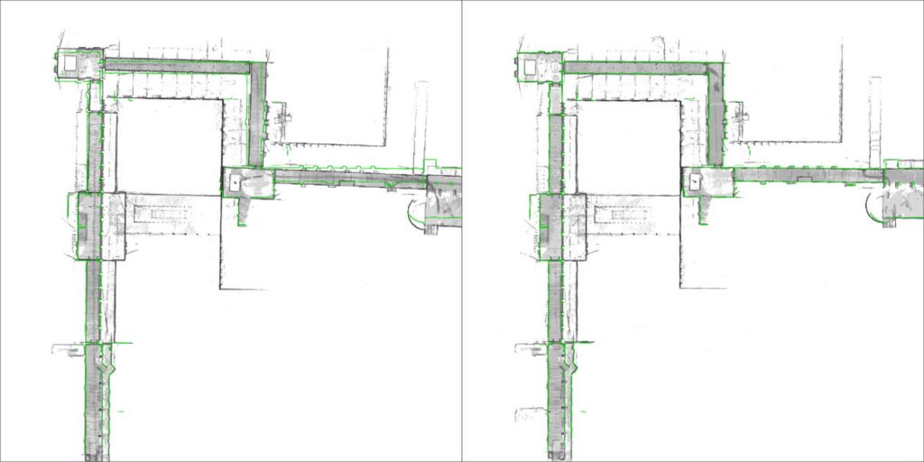
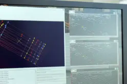
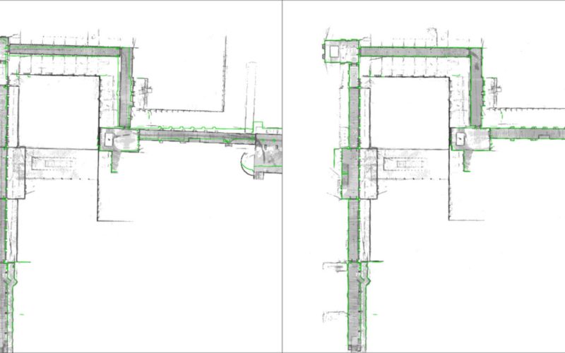
The green outline in the left image shows how the map deviates from the true structure with a conventional SLAM system where drift error has occurred, while the image on the right shows the significantly improved accuracy obtained with the new Precision SLAM technology
However, even when a device captures highly accurate individual measurements, chaining them will result in an accumulation of noise and tiny measurement uncertainties. Over time, the estimated motion will start to deviate from the true motion, which is known as “drift error”. This can often be observed as a slight bending of long corridors that are actually straight. All available SLAM systems – regardless of whether these use LIDARs or other sensors – are inherently affected by this phenomenon.
The innovative NavVis Precision SLAM technology significantly reduces drift error and improves the SLAM accuracy. This is particularly evident in cases where complementary techniques such as loop closures cannot be deployed if, for example, the building’s layout does not allow for it. Precision SLAM even improves accuracy when SLAM anchors are used to incorporate ground control points into the mapping process.
Dr. Stefan Romberg, Head of Mapping and Perception at NavVis, said:
“I am very excited about our new Precision SLAM technology. We are always striving for the highest possible map and point cloud accuracy and improving SLAM is a critical component to being successful. It is widely known among SLAM developers and users that complementary approaches such as loop closures or ground control points are needed to achieve a high accuracy. However, with the Precision SLAM technology we have developed an approach that not only nicely complements the former techniques but is especially evident when these have little effect or cannot be used.”
For more information, please contact:
Munich Office:
Viktoria Langley
T: (+49) 89 7169 250 20
E: press@navvis.com
New York Office:
Evan McPhee
T: (+1) (646) 714-7016
E: press@navvis.com
About NavVis:
NavVis is a leading provider of high-end digital building technology for large commercial and industrial properties. Our cutting edge indoor mapping, visualization and navigation technology is being applied in every industry that uses, manages or builds indoor space. Digital building technology is benefitting everything from construction monitoring, facility management, and plant planning, to transportation hubs and multi-channel retailing.
Our products consist of: The M3 Indoor Mapping Trolley, a highly-accurate mobile scanning device that enables fully comprehensive digital data capture; the browser-basedIndoorViewer software brings this data to life by enabling users to access and interact with 3D building models and maps from any device; and our pioneering vision-based Indoor Navigation technology, which brings highly-accurate and intuitive navigation to indoor spaces, without the need for any additional infrastructure.
NavVis technology is being used by a growing customer base around the world that includes Siemens, BMW, Allianz, SAP and Deutsche Telekom.