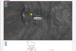
North Korea’s underground nuclear bomb test done in January 2016 has been mapped by Europe’s Sentinel-1a radar satellite.
When it happened, The United States Geological Service reported a 5.1 magnitude earthquake from the location and the China Earthquake Networks Centre reported the magnitude as 4.9.
Satellite interferometry is perfect for assessing the damage, as it works by finding the difference in “before” and “after” radar pictures of the Earth’s surface, even when the ground movements were quite subtle.
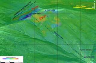
The deep blue colour indicates subsidence; the yellows show uplift.
Credit: Copernicus/ESA/BGR
Sentinel-1a got its first view of the test site following the explosion on 13 January, and this was compared with an observation acquired on 1 January.
The effects of both subsidence and uplift are evident. With the Sentinel-1b launched into orbit, which is planned for today, 22 April, the re-visit time of satellites in the certain location will shorten to only 6 days.
In the past the location of nuclear tests was based only on seismological data and Sentinel-1a refines these estimates further.
The imagery was released by Germany’s Institute for Geosciences and Natural Resources (BGR) and presented at the European Geosciences Union General Assembly.
Source: Copernicus