Retrieval of a Temporal High-Resolution Leaf Area Index (LAI) by Combining MODIS LAI and ASTER Reflectance Data
Retrieval of a Temporal High-Resolution Leaf Area Index (LAI) by Combining MODIS LAI and ASTER Reflectance Data
– Yonghua Qu , Wenchao Han and Mingguo Ma
Abstract:
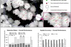
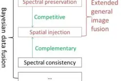
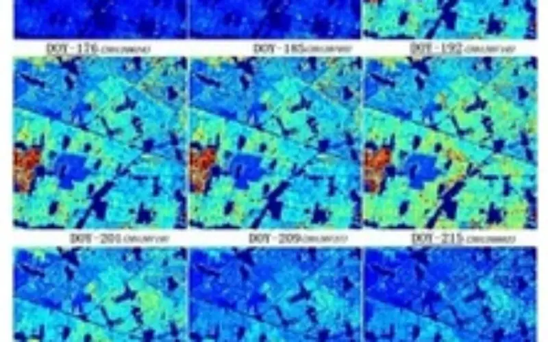
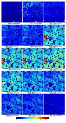 This paper aims to retrieve temporal high-resolution LAI derived by fusing MOD15 products (1 km resolution), field-measured LAI and ASTER reflectance (15-m resolution). Though the inversion of a physically based canopy reflectance model using high-resolution satellite data can produce high-resolution LAI products, the obstacle to producing temporal products is obvious due to the low temporal resolution of high resolution satellite data. A feasible method is to combine different source data, taking advantage of the spatial and temporal resolution of different sensors. In this paper, a high-resolution LAI retrieval method was implemented using a dynamic Bayesian network (DBN) inversion framework. MODIS LAI data with higher temporal resolution were used to fit the temporal background information, which is then updated by new, higher resolution data, herein ASTER data. The interactions between the different resolution data were analyzed from a Bayesian perspective. The proposed method was evaluated using a dataset collected in the HiWater (Heihe Watershed Allied Telemetry Experimental Research) experiment. The determination coefficient and RMSE between the estimated and measured LAI are 0.80 and 0.43, respectively. The research results suggest that even though the coarse-resolution background information differs from the high-resolution satellite observations, a satisfactory estimation result for the temporal high-resolution LAI can be produced using the accumulated information from both the new observations and background information.
Keywords: leaf area index; dynamic Bayesian network; uncertainty analysis; high spatial resolution; high temporal resolution