
Tag "Drone"

DroneDeploy Launches Real-Time Mapping for Instant Aerial Data and Analysis
Live Map Creates Instant Drone Maps on iOS Devices, Allowing Decision-Makers to Take Immediate Action SAN FRANCISCO – February 15, 2018 – (BUSINESS WIRE)–DroneDeploy, the leading drone mapping software platform in the
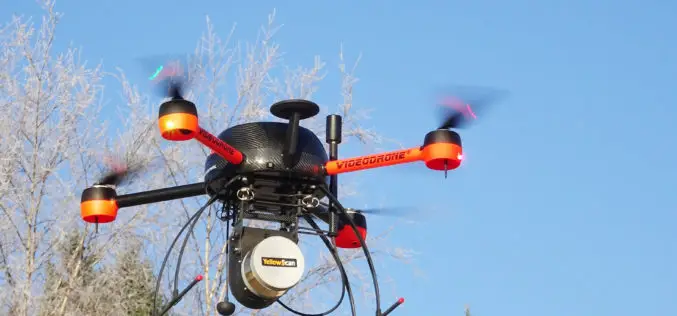
AirGon LLC Appointed North American Distributor for YellowScan Drone LiDAR Systems
Montpellier, February 13, 2018 – AirGon LLC, a wholly owned subsidiary of GeoCue Group Inc., has been appointed the North American Distributor for YellowScan based in Montpellier, France. Under the agreement, AirGon
PrecisionHawk Acquires Droners.io and AirVid to Launch the Nation’s Largest Network of Commercially Licensed Drone Pilots
PrecisionHawk will merge the two companies under the Droners.io name and platform to support the delivery of on-demand, drone-based imagery to its enterprise clients Raleigh, NC – February 8, 2018
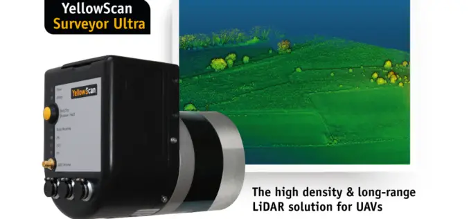
YellowScan Unveils Its New UAV-LiDAR System
Montpellier, 5 February 2018 – The Surveyor Ultra is the new system from YellowScan, integrating the Velodyne VLP-32C scanner & the Applanix APX-15 IMU. Thanks to its high-density (600 000 shots per second), the

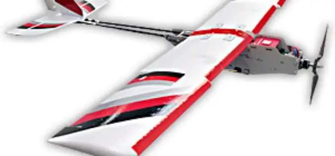
Delair Introduces Industry’s Most Advanced Fixed-Wing UAV for LiDAR-Based Aerial Surveying and 3D Mapping
New Delair DT26X LiDAR drone combines LiDAR sensing with RGB camera data to enable highly accurate and high-resolution 3D representation and measurement over large areas with minimal flights and in

IIT-Roorkee Professor Develops New Technology for Aerial Survey
According to recent news by the Hindustan Times, Professor Kamal Jain at the civil engineering department of the IIT used a drone for taking videos with an interactive web map to demonstrate

PrecisionHawk Secures $75 Million to Foster Global Adoption of Commercial Drone Technology
Raleigh, NC – January 24, 2018 – PrecisionHawk, Inc. – a leading provider of drone technology for the enterprise – announced today it has raised a $75 million round of
SRA Mumbai to Use Drone to Map Slums
According to recent news reported by the Times of India – the Slum Rehabilitation Authority (SRA) will use a high-end drone for accurate mapping of slums across the metropolis. SRA chief executive officer Deepak Kapoor confirmed to
YellowScan and Geotrim Sign a Distribution Agreement for Finland
Montpellier, 15 December 2017 – YellowScan and Geotrim have concluded a distribution agreement for Finland. Headquartered in Vantaa, Geotrim is the Finnish Distributor of Trimble Geomatics solutions with long time experience
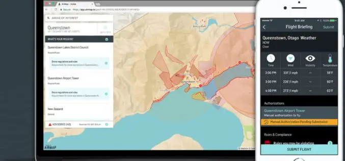
AirMap Expands to New Zealand with Airways UTM Trial
December 12th, 2017 – Big news for Kiwi drone pilots: we’ve joined forces with Airways to bring digital airspace authorization to New Zealand’s drone community. Beginning today, drone operators can use AirMap’s
