
Tag "Drone"

Get Ready for the New Small Drone Rule!
A new world of opportunities for drone operators opens next week on August 29 when the new small drone rule for non-hobbyists becomes effective. The Federal Aviation Administration (FAA) wants

The Drone Leader DJI Will Exhibit in Europe for the First Time At The Most Important Drone Trade Show, ExpoDronica
Chinese drone manufacturer DJI, the world leader in sales, will exhibit at the second edition of Expodrónica Drone Trade Show in Zaragoza next 22nd and 23rd September. It will be

Terra Drone and Hitachi Construction Machinery Announce Partnership to Advance UAV Land Surveying
TOKYO, July 26, 2016 — (PRNewswire) — Terra Drone, Asia’s leading service provider of unmanned aerial vehicles (UAV), and Hitachi Construction Machinery, the world’s leading manufacturer of construction and mining equipment,
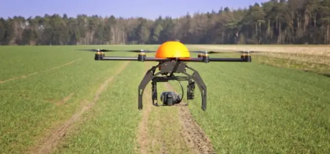
Agricultural Drone Market Size Anticipated to Achieve Over USD 555 Million at a CAGR of 21% from 2016 to 2023
According to a market research report published by Global Market Insights, the agricultural drones market size was valued over USD 135 million in 2015 and is anticipated to achieve over

A New Mobile Phone App for Grassroots Mapping
University of Exeter academics have created an app which could help aid humanitarian rescue work in disaster-struck regions by using geographic data to map landscapes. The android mobile phone application

Minister of Railways Launches One E-enabled application for Proper Monitoring of all the Railway Projects
Minister of Railways launches one E-enabled application, namely, Project Management & Information System (PMIS) for proper Monitoring of all the Railway projects throughout the country This Application will be able
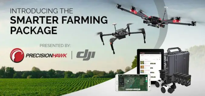
PrecisionHawk And DJI Deliver Easy-To-Use Drone And Data Packages For Farmers
The pre-assembled package, which includes DJI’s hardware platform plus PrecisionHawk’s flight and analytics software, is seamlessly integrated to provide a cost-effective and easy remote sensing tool for agriculture PrecisionHawk and

GAIL to Use Drones to Secure Gas Pipelines
GAIL India, the country’s biggest gas transporter, will deploy drones on a pilot basis on its main trunk pipeline as part of higher safety measures it is implementing to secure
MDDA Ready for Drone To Detect Encroachment
Dehradun: Mussoorie Dehradun Development Authority (MDDA) is set to conduct a 15-day trial of a drone to monitor illegal constructions and encroachments from March 8, which will help staff to

World Campus Remote Sensing Certificate Helps GIS Professionals Use Drone Data
UNIVERSITY PARK, Pa. — Drones are suddenly everywhere — gathering crop data, monitoring air pollution, helping with search-and-rescue missions and even taking “drone selfies.” But the increase of data collection
