![]() GAIL India, the country’s biggest gas transporter, will deploy drones on a pilot basis on its main trunk pipeline as part of higher safety measures it is implementing to secure its vast network.
GAIL India, the country’s biggest gas transporter, will deploy drones on a pilot basis on its main trunk pipeline as part of higher safety measures it is implementing to secure its vast network.
In the aftermath of the June 2014 accident at its pipeline in Andhra Pradesh that killed at least 18 people, the state-owned firm has taken a number of initiatives to raise safety standards including replacing old pipelines and using advanced technology.
“We plan to use drones on a pilot basis on a 200-km stretch of the HBJ pipeline in the Chambal Ravines in Madhya Pradesh,” GAIL Director (Projects) Ashutosh Karnatak told PTI.
The company has already tendered for drones and the response has been encouraging. “We hope to award the tender in a months time,” he said.
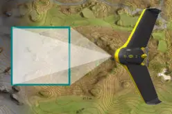
The drones will be used to patrol the pipeline to detect physical abnormal activity like encroachment or intrusion on the pipeline.
GAIL India has also started using satellite surveillance to monitor its 13,000-km of the gas pipeline network.
A government probe into the June 2014 accident had highlighted safety lapses at the firm and prompted sector regulator Petroleum and Natural Gas Regulatory Board (PNGRB) to slap a penalty.
Karnataka said drones will be used to detect encroachments around pipelines as they are a big safety hazard.
In the pilot, a drone will fly over the pipeline, capturing pictures, and other data using smart technology. The data will be analysed to detect any potential hazard.
“We estimate a drone may cost Rs 2.5 crore or so,” he said adding the company is experimenting if technology can replace patrolling.
If successful, drones will be used on other key pipelines.
GAIL, at present, uses foot patrolling to spot encroachments and seeks local administration’s help in getting them cleared.
Drones will however not be able to detect any leakage, for which the company will continue to relied on sensors and patrolling, he said.
“We started using live satellite monitoring of the pipelines this year and we are now integrating advanced Unmanned Ariel Vehicle (UAV) with this system,” he said.
Pipeline securities is a major issue across the world and with recent progress in satellite sensing technology, availability of new high-resolution satellites and object-oriented image analysis, there is a possibility to introduce space technology for pipeline monitoring applications.
GAIL did pilot project on satellite monitoring on its 610 km Dahej-Vijaipur pipeline.
– PTI