
Tag "geospatial"
India Geospatial Stack to Enable Scientific Mapping of Resources
Contributed by – From the 14% at the time of independence to almost 32% according to the 2011 Census, urban settlements in India have witnessed a rapid population growth –
USGIF Announces 2020 Achievement Award Winners
Outstanding organizations and individuals recognized for contributions to the geospatial intelligence community Herndon, Virginia (April, 21,2020)— The United States Geospatial Intelligence Foundation (USGIF) is pleased to announce the 2020 recipients

TCarta Opens Jamaica Office to Provide Geospatial Services to Caribbean Region
DENVER, Colorado, USA, 6 November 2019 – TCarta Marine, a global provider of geospatial products and services, has opened an office in Kingston, Jamaica. Officially operating as a separate Jamaican

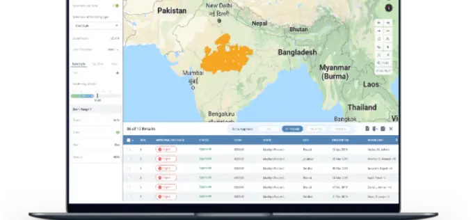
One Stop Geospatial Search Engine
Contributed By: Note: Here, URLs mean link of documents, examples, scripts, downloadable geospatial data, geospatial services, tools, templates, web applications and mobile apps etc. which are in PUBLIC domain (i.e. available online). Geospatial

Geospatial Commission UK to Launch £1.5 Million Geospatial Competition
The Geospatial Commission has partnered with Innovate UK to launch a new government competition, where organisations can apply for a share of £1.5 million to fund projects which use data
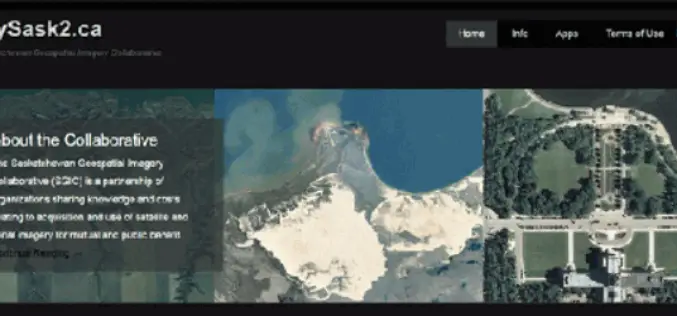
CubeWerx Signs Multi-year Contract to Provide Managed Imagery Services to SGIC
Gatineau, QC, Canada, November 13, 2018 – CubeWerx announced today it has signed a four-year contract to provide managed imagery services to the Saskatchewan Geospatial Imagery Collaborative (SGIC). CubeWerx successfully completed porting
PrecisionHawk Chosen as DJI’s New Provider of Airspace Data in North America
PrecisionHawk’s Low Altitude Traffic and Airspace Safety (LATAS) platform to replace AirMap PrecisionHawk, Inc. today announced a partnership with DJI, the world’s leader in civilian drones and aerial imaging technology, to improve
Spottitt Launches Cloud-Based Geospatial Data Analysis on DNV GL’s Veracity Platform
Online Imagery Portal with Analytics HARWELL, United Kingdom, 9 October 2018 – Spottitt Ltd. has launched a cloud-based workspace that puts massive satellite imagery sources and advanced analysis capabilities at
Extensis and LizardTech Unite as One Company
Combined company helps organizations increase the ROI and value of their digital assets, fonts, and large imagery Portland, Ore.―October 2, 2018 – Extensis® and LizardTech today announced they are uniting

Pix4D Accelerates Growth with A New Office in Madrid
A centre of innovation in the heart of Spain Lausanne, Switzerland: On November 1st 2018, Pix4D opens a new R&D office in Madrid. It is the company’s fifth office after
