
Tag "GIS software"

Supergeo Invest in Innovative Geographic Network Analysis for Next Generation GIS Products
Supergeo Technologies, a leading global provider of GIS software and solutions, announces the investment plan in advanced geographic network applications. The technology collaboration is conducted by Supergeo and the Department

The Geographic Calculator 2014, SP1 Now Available with New Jobs to Streamline Workflow
Hallowell, Maine – July 22, 2014 – Blue Marble Geographics (bluemarblegeo.com) is pleased to announce the release of the Geographic Calculator 2014 Service Pack 1 (SP1). This interim release features new
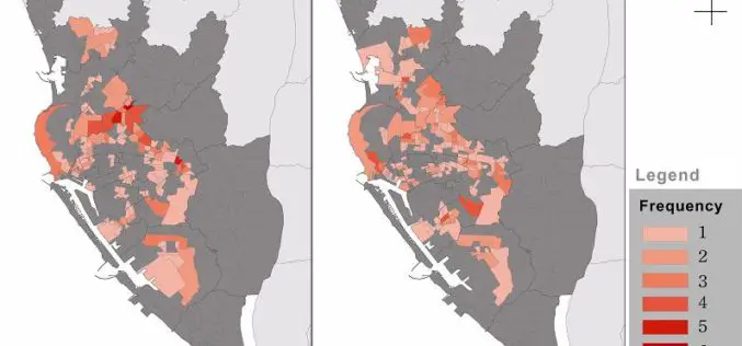
Dengue Fever Control and Prevention via GIS Technologies
Controlling and preventing infectious diseases like dengue fever is one of the main issues for public health authorities in many countries. GIS technologies can play a key role to support

Predict the Champion of 2014 FIFA World Cup with SuperGIS
Who will be the winner of World Cup 2014? Supergeo holds a vote for predicting the winner of 2014 FIFA World Cup to let worldwide football fans participate in the
India Lingaraj College Selects SuperPad for Precise Data Collection
Supergeo Technologies, a leading global provider of GIS software and solutions, announced that Lingaraj College of K.L.E. Society in India selects SuperPad 3.1a to enhance geospatial data collecting efficiency and
Latest SuperGIS Desktop Enhances Editing Performance and Functionality
Developed by Supergeo, the updated SuperGIS Desktop 3.2 now provides users with a more powerful and comprehensive platform to display and edit GIS data by strengthening the performance, stability and
SuperGIS Training Centre Established in Geomatika University College
To well promote GIS technologies and professionally train our next generation in creating a better world, Supergeo Technologies Inc. cooperates with Geomatika University College (GUC), Malaysia to establish SuperGIS Training
SuperSurv M3 Flash Sale for Cost-Effective Field Data Collection
Supergeo Technologies, a leading global provider of GIS software and solutions, announces that SuperSurv M3, the professional mobile GIS app for Android and iOS powered devices, is now on 50%
Supergeo Launches Mobile Cadastral GIS 3.2
Supergeo announced that Mobile Cadastral GIS 3.2 is officially launched for field surveyors to timely query and measure cadastral data on site with their Android devices. Mobile Cadastral GIS 3.2
Better Infectious Rickettsioses Prevention in Taiwan with SuperGIS Desktop
The professional GIS desktop software, SuperGIS Desktop, supports Dr. Chung-Hsu Lai, I-Shou University, Kaohsiung, Taiwan, in the research of human spotted fever group rickettsioses, SFGR, to provide geographical relations of
