
Tag "Light Detection and Ranging"

BAE Systems to Develop Airborne Mine-Hunting LIDAR for Manned and Unmanned Aircraft
Electro-optics engineers at BAE Systems are designing a multi-sensor suite and onboard processing to detect, identify, and pinpoint moored and drifting sea mines from manned and unmanned aircraft. Officials of the

Philippine Use LiDAR to Maps out Renewable Energy Resources
The Department of Science and Technology (DOST), Government of Philippine for applications of its Light Detection and Ranging (LiDAR) technology and maps out possible renewable energy resources through the PhiLiDAR
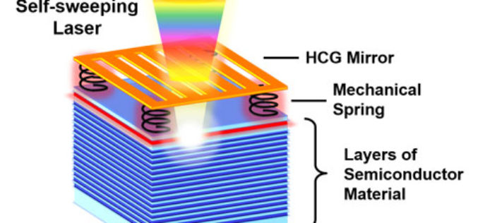
Self-Sweeping LiDAR Could Dramatically Shrink 3D Mapping Systems
A team of UC Berkeley engineers led by Connie Chang-Hasnain, a professor of electrical engineering and computer sciences, used a novel concept to automate the way a light source changes
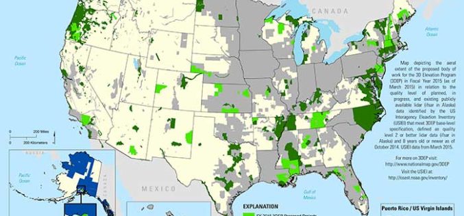
State and Regional 3DEP Stakeholder Workshops Underway
The U.S. Geological Survey National Geospatial Program is developing the 3D Elevation Program (3DEP) to respond to growing needs for high-quality topographic data and for a wide range of other
Forest Canopy LAI and Vertical FAVD Profile Inversion from Airborne Full Waveform LiDAR Data Based on a Radiative Transfer Model
Forest Canopy LAI and Vertical FAVD Profile Inversion from Airborne Full Waveform LiDAR Data Based on a Radiative Transfer Model – Han Ma, Jinling Song and Jindi Wang Abstract: Forest

DOST-UP’s Plane to Fly in ARMM to Chart Hazard Map
Manila, April 29 — The Department of Science and Technology (DOST) will fly a plane over the Autonomous Region of Muslim Mindanao in August to survey the region for hazard preparedness. The
