
Archive
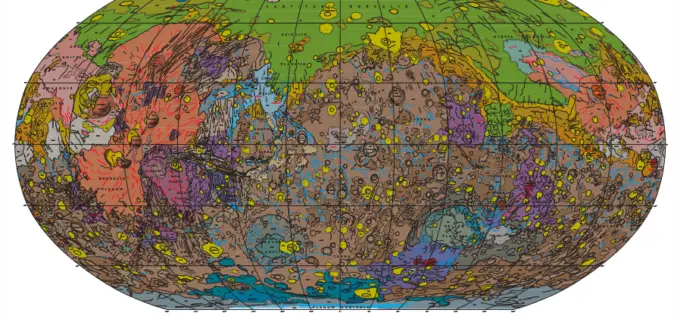
Geologic Map of Mars
Geologic Map of Mars Abstract This global geologic map of Mars, which records the distribution of geologic units and landforms on the planet’s surface through time, is based on unprecedented

Webinar: Smart City Solutions with Interactive 3D GIS Technologies
Smart City Solutions with Interactive 3D GIS Technologies Feeling not enough about traditional 2D maps? With SuperGIS 3D Earth Server, you can see different features and explore spatial relations on
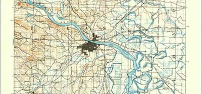
Revised Arkansas and South Carolina Maps Feature New Design
Newly designed US Topo maps covering Arkansas and South Carolina are now available online for free download US Topo maps now have a crisper, cleaner design – enhancing readability of maps
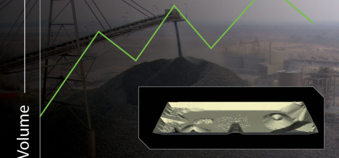
New Automated Stockpile Volume Solution Launches
3D Laser Mapping Brings Fast, Cost Effective Automated Volume Measurement To The Mining Industry 3D Laser Mapping has announced SiteMonitorSV as the latest offering from its suite of SiteMonitor solutions.

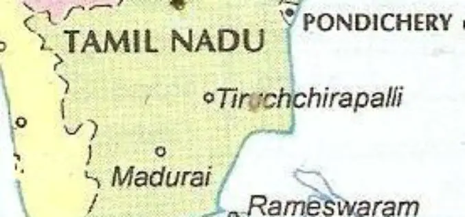
Institute of Forest Genetics and Tree Breeding to Map Trees in Tamil Nadu using GIS
In recent news, the Institute of Forest Genetics and Tree Breeding (IFGTB) is going to do Geographical Information System (GIS) based mapping of tress in all 32 districts of Tamil

Philippine National Irrigation Systems Upgrades Parcel Maps by SuperGIS Desktop
Supergeo Technologies, a leading global provider of GIS software and solutions, announces that Philippines National Irrigation Systems (NIA) upgrades the country’s parcellary maps through SuperGIS Desktop to elevate the efficiency
SuperGIS Spatial Statistical Analyst 3.2 Released Globally
Supergeo Technologies, a leading global provider of GIS software and solutions, officially launches SuperGIS Spatial Statistical Analyst 3.2 with powerful functions and optimization of interface for worldwide users. SuperGIS Spatial

Ordnance Survey: New off-Road Cycle Trail Maps Launched in Hampshire
Ordnance Survey has identified Hampshire as one of the nation’s main cycling hubs and has developed a set of mapping packs containing a range of off-road routes, enabling cyclists to explore

Vietnam to Use Remote Sensing in Agriculture
In recent news, Vietnam is gearing up to use Remote Sensing to boost its agricultural production. In a conference last week Le Quoc Doanh, Deputy Minister of Agriculture and Rural
Tamil Nadu Integrates GIS Mapping to Check on School Dropouts
Tamil Nadu would be the first state in the country to integrate Geographical Information System (GIS) mapping with the education management information system to check on school drop outs, IT
