
Archive
Modeling Aboveground Biomass in Dense Tropical Submontane Rainforest Using Airborne Laser Scanner Data
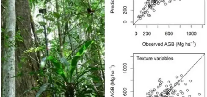
Modeling Aboveground Biomass in Dense Tropical Submontane Rainforest Using Airborne Laser Scanner Data – Endre Hofstad Hansen, Terje Gobakken, Ole Martin Bollandsås, Eliakimu Zahabu and Erik Næsset Abstract: Successful implementation of projects

PCI Geomatics announces strategic partnership with MDA for Accessing RADARSAT-2 Imagery
PCI Geomatics, a world leading developer of remote sensing and photogrammetric software and systems, announced today a strategic partnership with McDonald, Dettwiler and Associated Ltd. (MDA). The partnership introduces a solution that
New Nebraska Maps Feature Trails
Newly released US Topo maps for Nebraska now feature trails provided to the USGS through a “crowdsourcing” project operated by the International Mountain Biking Association (IMBA). Several of the 1,376

SuperGeo Webinar: Top 10 Features SuperGIS Desktop
SuperGeo Webinar: 10 Most Useful Features of SuperGIS Desktop 5th February, 11:00 AM – 11:30 AM (India Standard Time) Are you looking for powerful and comprehensive GIS solutions? Something that may

Call for Papers: A Special Issue of Remote Sensing of Environment on Landsat 8 Science Results
With the launch of the Landsat Data Continuity Mission (LDCM) in February 2013, the already unprecedented Landsat global record continues and could reach 50 years or longer in length.

US Army Corps of Engineers Selects SimActive for Drones
SimActive Inc., a world-leading developer of photogrammetry software, has been selected by the United States Army Corps of Engineers (USACE). They join professionals across the globe using Correlator3D™ with UAV

W3C and OGC to Collaborate to Integrate Spatial Data on the Web
6 January 2015 — The W3C and the Open Geospatial Consortium (OGC) announced today a new collaboration to improve interoperability and integration of spatial data on the Web. Spatial data

EUROGEO Conference on Communicating Geography: serving our world
Communicating Geography: serving our world 21-22 May 2015, Ankara, Turkey About Ankara Although it was a small town before the proclamation of the republic in the early 1900s, Ankara today
SuperGIS Cache Generator Now Supports STP Format
Supergeo announces that Cache Generator, the built-in tool in SuperGIS Desktop 3.2, now supports STP format, as a faster alternative to STC and XML files, for users to experience a

SuperGIS Helps National Research Council of Italy to Analyze Earth System
Supergeo Technologies, the global leading GIS software and solution provider, announced that Institute of Geosciences and Earth Resources, National Research Council of Italy (CNR) utilizes SuperSurv and SuperGIS Desktop to
