
Archive

Sahaaya App to Help Bengaluru Citizens in Civic Woes
In recent news, Bruhat Bangalore Mahanagara Palike (BBMP) has launched Sahaaya app, a GIS-based interface, to help citizens lodge complaints regarding civic woes. BBMP Sahaaya (Help) is a easy and user friendly

Blue Marble to Highlight Use of Global Mapper for the Military
Blue Marble Geographics (bluemarblegeo.com) will be exhibiting at the 26th Annual SO/LIC Symposium & Exhibition held in Washington, D.C. at the Washington Marriott Wardman Park Hotel on January 26-28, 2015.
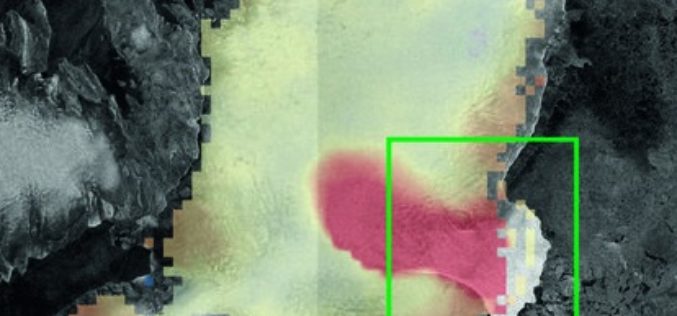
Satellites Catch Austfonna Rapid Ice Loss
Rapid ice loss in a remote Arctic ice cap has been detected by the Sentinel-1A and CryoSat satellites. Located on Norway’s Nordaustlandet island in the Svalbard archipelago, parts of the

Exelis Webinar: Increase Agricultural Efficiencies Using Satellite Imagery
Exelis Webinar on Increase Agricultural Efficiencies Using Satellite Imagery February 5, 2015 As anyone living in a major drought region will tell you, water has become the new gold. Properly conserving and

Esri Training Seminar: Streamline GIS Workflows with ArcGIS Pro
Streamline GIS Workflows with ArcGIS Pro Thursday, January 29, 2015 Seminar Overview: ArcGIS Pro is a new desktop application included with ArcGIS 10.3 that is designed to help GIS professionals

Google to End Support for Google Maps Engine
In an official Google user group, it has been informed that Google will end support for the Google Maps Engine. Google will provide support for the Google Maps Engine (GME) product
Esri Releases Demographic Data for 137 Countries
Global Income, Population and Business Data Now Easily Available for Better Local Market Knowledge Esri announces that geodemographic information for 57 additional countries has been added to its ready-to-use ArcGIS

OGC Adopts IndoorGML Standard for Encoding Indoor Navigation Data
The Open Geospatial Consortium (OGC) membership has approved the OGC IndoorGML Encoding Standard. This OGC standard specifies an open abstract data model and XML schema for indoor spatial information. The
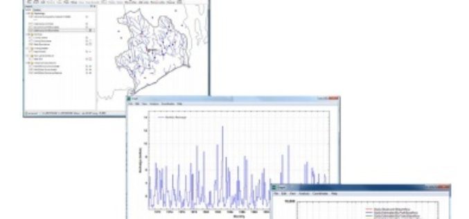
U.S. Geological Survey Groundwater Toolbox, a Graphical and Mapping Interface for Analysis of Hydrologic Data
U.S. Geological Survey groundwater toolbox, a graphical and mapping interface for analysis of hydrologic data (version 1.0): user guide for estimation of base flow, runoff, and groundwater recharge from streamflow
One Week Course About UAV Remote Sensing Principles
It is a one week course about state of the art remote sensing techniques using UAV aerial images. A broad board of top level UAV professionals and researchers has been
