
Archive

Government Orders Installation of GPS in All Cabs Plying In Delhi
New Delhi: In order to ensure women safety, Delhi Government has ordered all taxi operators to install GPS in their vehicles, failing which fitness certificate will not be issued to

University of Bristol Looking for Post-Doctoral Research Assistant in Computational Volcano Geodesy
The University is internationally renowned, ranked in the top 30 universities globally (QS World University Rankings), due to its outstanding teaching and research, its superb facilities and highly talented students
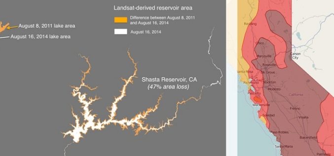
Drought Monitoring and Visualization with Open Data
Drought is condition when a region notes a deficiency in its water supply whether surface or underground water. A drought can last for months or years, or may be declared after
PAOneStop Online Tool for Farmers to Map Farm
The Penn State Cooperative Extension Land Analysis Lab has developed PAOneStop, an online tool for farmers. PAOneStop provides online tools to help farmers meet regulatory requirements for Conservation and Nutrient Management
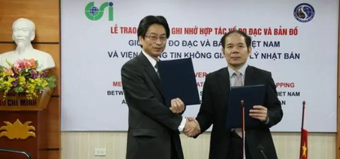
Vietnam and Japan Signed MoU to Cooperate in Geospatial Sector
The Vietnam Department of Survey and Mapping (VDSM) and the Geospatial Information Authority of Japan (GSI) exchanged a Memorandum of Understanding (MoU) on March 11 in Hanoi to commit to
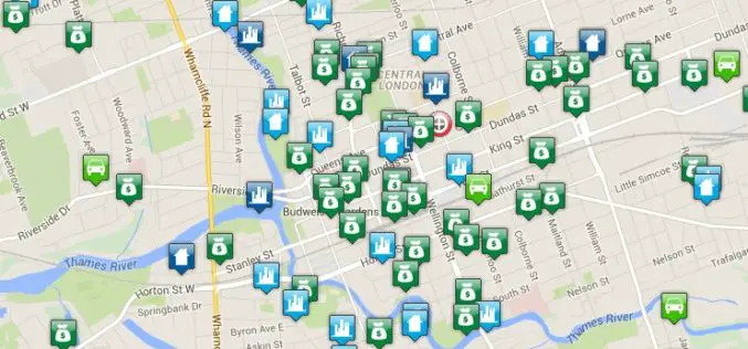
Crime Mapping Tool for Better Crime Monitoring
Bair Analytics Inc. will be providing online crime mapping service to the London Police Service and public. Each occurrence is represented by an icon that, when selected, will reveal information about each
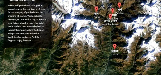
Climb the Mount Everest with Google Street View
Google has added the Khumbu region of Nepal, famously known as the Mount Everest region, to its Street View with extensive mapping and photographs. Google has now taken street view
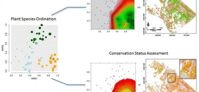
Gradient-Based Assessment of Habitat Quality for Spectral Ecosystem Monitoring
Gradient-Based Assessment of Habitat Quality for Spectral Ecosystem Monitoring – Carsten Neumann , Gabriele Weiss, Sebastian Schmidtlein, Sibylle Itzerott, Angela Lausch, Daniel Doktor, and Maximilian Brell Abstract: The monitoring of ecosystems alterations has become a crucial

Webinar – A New Standard: Commercial Geiger-mode LIDAR
A New Standard: Commercial Geiger-mode LIDAR Tue, Mar 24, 2015 10:30 PM – 11:30 PM IST (Show in My Time Zone) Harris Corporation has developed the first commercially-available Geiger-mode LiDAR
Climate Change Vulnerability Index System
To handle climate changes and reduce the loss of lives and properties, Taiwan government establishes a SuperGIS-powered platform, to provide latest information to support decision making. To address climate changes
