
Archive
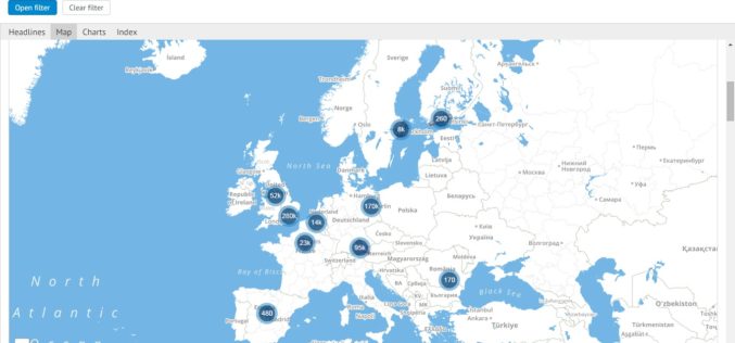
Mapping Europe’s Startup Business
The European Commission has recently announced the launch of a dynamic mapping project to map the scale of the startup ecosystem across Europe. This platform is being developed as part of Startup Europe to
Esri Managed Cloud Services Receives Census Bureau Authorization
Redlands, California— Esri Managed Cloud Services has achieved an agency Authorization to Operate (ATO) at the moderate level from the US Census Bureau. Esri worked with the bureau to build and

MapmyIndia Launches GPS Based SafeMate
MapmyIndia has recently launched GPS based SafeMate, a dedicated, personal safety device for women, children and families. SafeMate is small, lightweight and portable – the size of a matchbox –

Indoor Mapping Project Attracts Funding from Google
School of Information Studies (iSchool), Syracuse University, Assistant Professor Yun Huang has received funding from Google’s Faculty Research Awards Program that will help her continue research on an indoor mapping project. The

Real Time World Air Quality Mapping
Recently, aqicn.org has published Air Quality mapping information system in real-time for over 70 countries. The data is continuously collected, gathered and processed in real-time from more than 5900 feeds. Only

Drone Connector Now Features Over 700 Professional Drone Operators in Over 90 Countries
senseFly’s global service network, Drone Connector, now features over 700 professional drone operators, which it connects with organisations that require their help to produce geo-referenced imagery and data products. Created

Webinar on Image Centric GIS for Complete Geospatial Processing Using ENVI & ArcGIS
Improvements in the quality and availability of geospatial imagery in recent years has driven organizations to include geospatial imagery as an integral part of their GIS strategy. While this trend

Geospatial Information Systems Specialist Course
Geospatial Information Systems Specialist Course GIS Specialist for Incident Management Utilizing advanced GIS skills to support incidents Tuesday, March 8, 2016 to Thursday, March 10, 2016 Redmond, OR, USA National Wildland
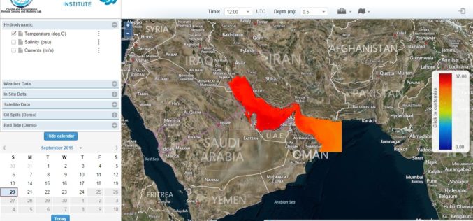
Remote Sensing for Real Time Coastal Monitoring
The Masdar Institute of Science and Technology (MI) has announced that it has launched an environmental regional observatory (http://earth.masdar.ac.ae/), offering comprehensive information for monitoring coastal processes in the UAE and

MAPPS Comments on Pipeline Safety
Calling for enhanced mapping and location data for the Nation’s pipelines, MAPPS submitted a statement on Friday to the Surface Transportation and Merchant Marine Infrastructure, Safety, and Security Subcommittee of