
Archive

Drones Helping to Conduct High-Resolution Remote Sensing
New York: Earth and environmental scientists are relying on affordable advanced technological drones to conduct long-term high-resolution experiments at a much lower cost than using aircraft or satellites. Unmanned Aerial Vehicles
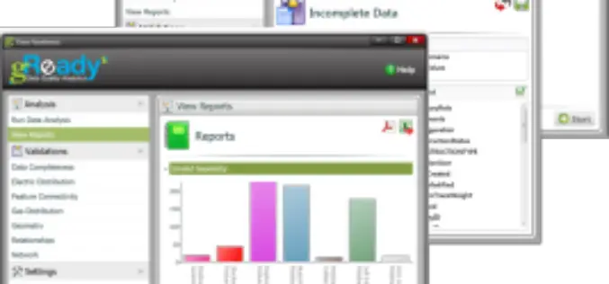
RAMTeCH Optimizes GIS Data Quality with gReady
RAMTeCH Software Solutions, Inc., a global leader in spatial enterprise solutions, introduces its gReady™ data quality analytics software solution to help uncover, prioritize and correct operational data quality errors in Geographic Information

Combining SAR and Optical Imagery for Mapping and Change Detection
PCI Geomatica Webinar: Combining SAR and Optical Imagery for Mapping and Change Detection February 25, 2016 | 4:00 AM EST – 9:00 AM (GMT) | 2:00 PM EST – 7:00 PM (GMT) PCI

Advanced Webinar on Using NASA Remote Sensing for Flood Monitoring and Management
Advanced Webinar on Using NASA Remote Sensing for Flood Monitoring and Management When: 03/16/2016 to 04/06/2016 Times: 8:00 a.m. – 9:00 a.m. EDT (UTC-4) and 4:00 – 5:00 p.m. EDT (UTC-4)
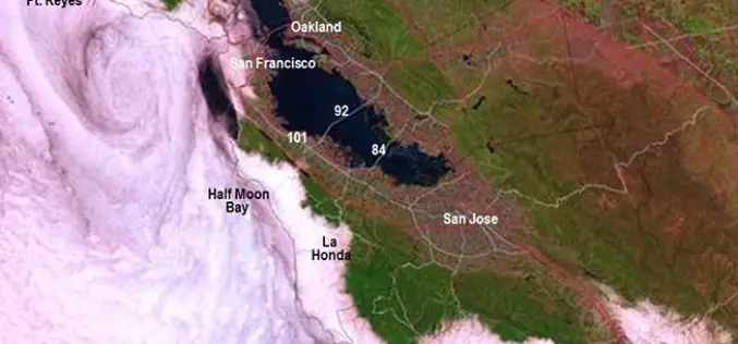
New California Fog Maps Reveal Pictures for Planning
A new series of maps of fog and low clouds covering the northern and central California coasts reveals daytime and nighttime patterns with a level of detail never previously mapped.
Hera Systems Unveils Groundbreaking $1 Pricing for Satellite Imagery
Simple Pricing Ranges from $1-$3 for Archived and Freshly Tasked High-Resolution Imagery SAN JOSE, Calif. – Hera Systems has unveiled the industry’s most aggressive, simplest pricing for high-resolution satellite imagery

USGIF Scholarship Program Now Open
The USGIF Scholarship Program and the Ken Miller Scholarship for Advanced Remote Sensing are now open and accepting applications. The USGIF Scholarship Program annually awards doctoral, graduate, undergraduate, and graduating
Drones to Conduct Aerial Surveys of Mines for Coal India
KOLKATA: Coal India is planning to start using drones to conduct aerial surveys of mine blocks that come up for exploration and to assess the extent of greenery restored after

President’s 2017 Budget Proposes $1.2 Billion for the USGS
Reflects the ongoing commitment to scientific discovery and innovation to support decision making for critical societal needs WASHINGTON—The President’s fiscal year (FY) 2017 budget request for the U.S. Geological Survey

NHAI and WII to Develop GIS Maps of National Highways Passing Through Protected Areas
IANS | New Delhi – The National Highways Authority of India (NHAI) on Monday said it created a dialogue platform with stakeholders to mainstream sustainable development and environmental management in
