
Archive

BRICS Nations to Exchange Remote Sensing Data of the Earth
According to recent news by Sputnik News, The BRICS countries are working to implement an initiative of sharing information on the Earth’s remote sensing, which will allow to swiftly respond to emergency situations and disasters, Russia’s

North Korea’s Nuclear Bomb Test Mapped by Europe’s Sentinel-1a
North Korea’s underground nuclear bomb test done in January 2016 has been mapped by Europe’s Sentinel-1a radar satellite. When it happened, The United States Geological Service reported a 5.1 magnitude

OGC Requests Comment on Charter for Coordinate Reference System Standards Working Group
Members of the Open Geospatial Consortium (OGC®) request comments on the draft charter for an OGC Coordinate Reference System (CRS) Standards Working Group (SWG). The purpose of the OGC SWG
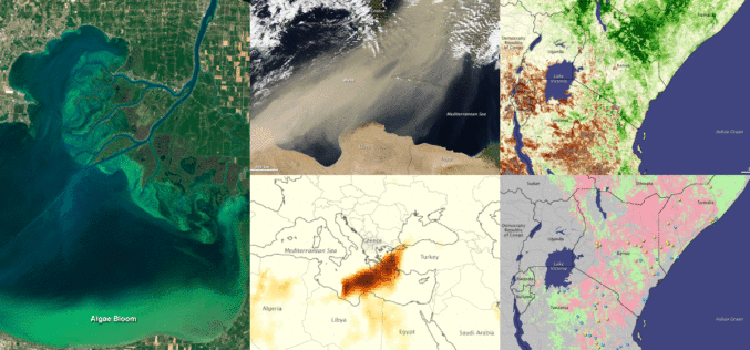
Fundamentals of Satellite Remote Sensing for Health Monitoring
NASA ARSET Training: Fundamentals of Satellite Remote Sensing for Health Monitoring 02 Jun. 2016 to 30 Jun. Times: 10:00-11:30 a.m. and 3:00-4:30 p.m. EDT (UTC-4) Predicting and monitoring disease outbreaks and environmental

Pakistan Inked Contract with China to Develop First Remote Sensing Satellite
According to recent news by The Nation, Pakistan Space & Upper Atmosphere Research Commission (SUPARCO) and China Great Wall Industry Cooperation (CGWIC) signed a contract on Wednesday for the development and
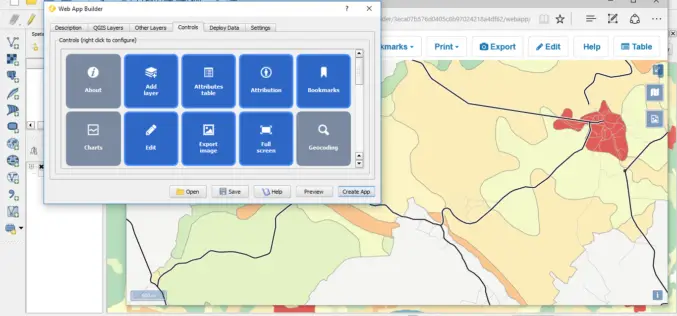
QGIS 2.14.1 Now Available from Boundless!
Boundless QGIS 2.14.1 is out the door! We are excited to share with your the latest offering of premier open-source desktop GIS technology. This release is available here and is

PhD Position: Methodological, Algorithm and Processing Chain Development for Analysis of Hyperspectral Image Data
The institute section “Land Surface” deals with the development of remote sensing methods based on various earth observation systems that are specifically adapted for the respective application scenarios. Key issues
GAIL to Use Drones to Secure Gas Pipelines
GAIL India, the country’s biggest gas transporter, will deploy drones on a pilot basis on its main trunk pipeline as part of higher safety measures it is implementing to secure

Notice Inviting Quotation for Supply of Total Station To IIT Patna
The Registrar, Indian Institute of Technology Patna invites quotations for supply of equipment details at ANNEXURE – I, in Single bid as indicated, in sealed cover, are hereby invited to
Punjab Government to Utilise Remote Sensing Satellites for Development
Punjab government on Monday said India should make use of its remote sensing satellites more efficiently for development in agriculture and rural and urban planning. “India, having the largest constellation
