
Archive
Chinese Internet Giant Baidu to Expand Mapping Services Abroad
According to recent news by the Shanghai Daily, Chinese Internet giant Baidu has recently announced that it will expand its mapping service to over 150 countries and regions by the
Boundless Sponsors American Geographical Society’s New AGS AP Teachers Fellows Program
Grant supports AP Human Geography teachers attending the AGS Annual Symposium Washington D.C – April 18, 2016 Boundless, the world leader in commercially supported open source GIS software, is proud

Drones Will Survey Progress for Railway Project
Indian Railways, for the first time, used drones to inspecting a mega rail project and assess the progress on the ground. These drones, unmanned flying machines, will now be used

The EARSC competition “European EO product of the year”
The EARSC competition “European EO product of the year” will encourage the use of open data from GEOSS (Global Earth Observation System of Systems) European Earth observation companies understand how

Insurance Company Using Drones for Crop Yields
According to recent news by the Business Standard, Private insurance companies are using drones to photograph farms and if permitted by the agriculture ministry these could provide data to calculate crop

Commercial UAV Expo 2016 at Las Vegas
Commercial UAV Expo is North America’s leading trade show and conference for the commercial drone market, focusing on: Surveying & Mapping Civil Infrastructure Process, Power & Utilities Aggregates & Mining Construction Law
What’s New in ArcGIS Earth 1.1
ArcGIS Earth, a free, desktop-based interactive globe that anyone can use to explore the world and work with a variety of 3D and 2D map data formats including KML. ArcGIS
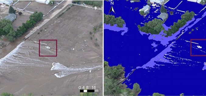
Mining Social Media to Task Satellite Data Collection During Emergencies
Combining satellite imagery with social media data enables a good match between predictions and observations in emergency situations. The era of Internet and social media has drastically changed the way
Tri-County Health Department Honors Esri Employee for Opioid Addiction Prevention Advocacy
Story Maps Provide Information on Local Resources and Help Celebrate Those Lost to Addiction Redlands, California—Jeremiah Lindemann, solution engineer at Esri, the global leader in geographic information system (GIS) software,

PCI Geomatics Expands Partnerships in Southern Africa
MARKHAM, Ontario, Canada—April 14, 2016: PCI Geomatics, a world leading developer of remote sensing and photogrammetric software and systems, announced today a renewed partnership with its reseller for Southern Africa.
